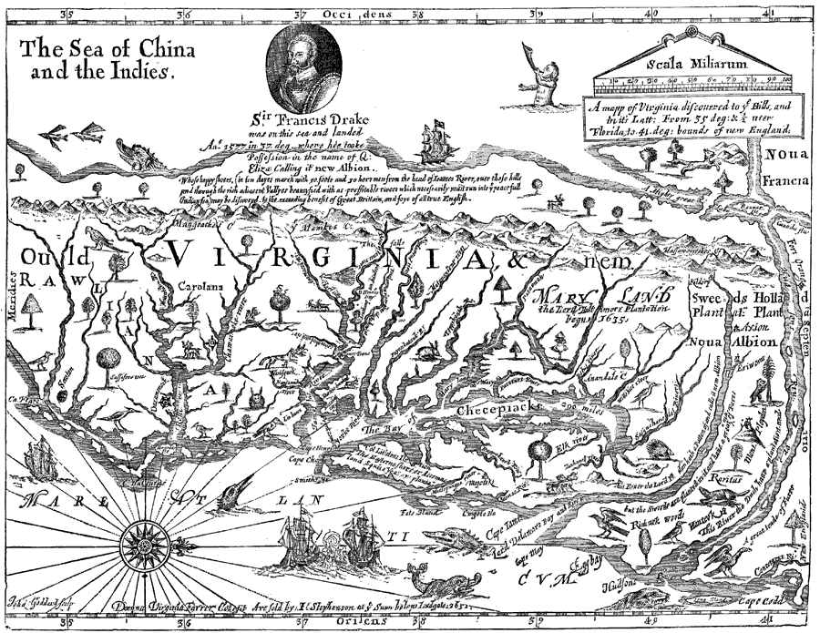
Description: A facsimile of an early map (1651) showing the discoveries of Sir Francis Drake in North America, including the coastline of Ould Virginia and Maryland, the Bay of Checepiake (Chesapeake Bay), Lord Delaware Bay, Cape Hatteras and Cape Fear, and the Sea of China and the Indies (Pacific Ocean) just beyond the mountains of Virginia. "In 1651, there was offered for sale in London, A Mapp of Virginia, compiled by ‘Domina Virginia Farrer,’ designating the territory on the Delaware as ‘Nova Albion,’ as well as ‘Sweed's Plantation,’ with a note: ‘This River the Lord Ployden hath a Patten of, and calls it New Albion; but the Sweeds are planted in it, and have a great trade of Furrs.’ On the Jersey side of the stream are indicated the sites of &lsquo:Richnek Woods,’ ‘Raritans,’ ’Mont Ployden,’ ‘Eriwoms,’ and ‘Axion,’ and on the sea–coast ‘Egg Bay,’ all of which are mentioned in Plantagenet's New Albion." — Winsor, 1884, p. 464.
Place Names: Early America 1400-1800, Bay of Checepiacke,�Chesapeake Bay, �Cape Codd, �Hudsons, �Noua Francia, �Virginia, �Maryland, �Carolana, �Cape Hatturas, �Colonial America, �Discovery, �New Sweden, �New Netherland, �New France, �Massachusetts, �Maryland, �New Englan
ISO Topic Categories: oceans,
location,
inlandWaters
Keywords: Virginia, physical, kEarlyMapsFacsimile, physical features, oceans,
location,
inlandWaters, Unknown, 1577
Source: Justin Winsor, Narrative and Critical History of America Vol. III (Boston, MA: Houghton, Mifflin and Company, 1884) 465
Map Credit: Courtesy the private collection of Roy Winkelman |
|