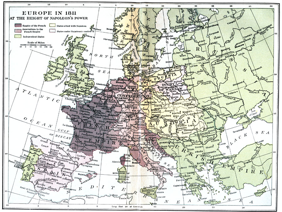
Description: "Napoleon was now at the zenith of his power. He ruled directly over an empire that was far larger than the former Kingdom of France. In 1809 he annexed what remained of the Papal States in Italy, together with the incomparable city of Rome, thus ending, for the time at least, the temporal power of the Pope. In 1810 he forced his brother Louis to abdicate the kingship of Holland, which country was now incorporated into France. He also...extended the empire along the northern coasts of Germany from Holland to Lübeck, thus controlling Hamburg, Bremen, and the mouths of the important German rivers...He was Emperor of a state that had 130 departments. He was also King of Italy, a state in the north-eastern part of the peninsula. He was Protector of the Confederation of the Rhine, which included all of Germany except Prussia and Austria, a confederation which had been enlarged since its formation by the addition of Westphalia and Saxony and the Grand Duchy of Warsaw, extending, therefore, clear up to Russia. His brother Joseph was King of Spain, his brother Jerome King of Westphalia, his brother-in-law Murat King of Naples...Russia was his willing ally...No ruler in history had ever dominated so much of Europe." — Hazen, 1917
Place Names: A Complete Map of Europe, France, �Greece, �Italy, �Portugal, �Spain, �Sweden, �French Empire, �Turkish Empire, �Kingdom of Prussia, �Confederation of the Rhine, �Duchy of Warsa
ISO Topic Categories: boundaries,
inlandWaters,
oceans
Keywords: Europe at the Height of Napoleon's Power, physical, �political, �historical, physical features, country borders,
major political subdivisions, boundaries,
inlandWaters,
oceans, Unknown, 1811
Source: Charles Downer Hazen, The French Revolution and Napoleon (New York, NY: Henry Holt and Company, 1917) 340
Map Credit: Courtesy the private collection of Roy Winkelman |
|