Sholes's Landing
| View Cart ⇗ | Info

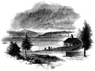
View from Shole’s Landing. This is a view from Chipman’s Point, or Sholes’s Landing, looking north. The high ridge on the right, in the distance, is Mount Independence. The higher and more distant hill on the left, over the cedar, is Mount Defiance, and the elevation beyond is Mount Hope. Fort Ticonderoga is on the other side of Mount Independence, in a line with the highest part.
Galleries
1763-1788 American Revolution PlacesSource
Benson J. Lossing, The Pictorial Field-Book of the Revolution (New York: Harper & Brothers, 1851)I:149
Downloads
2400×1799, 4.1 MiB
1024×767, 267.0 KiB
640×479, 112.5 KiB
320×239, 30.8 KiB