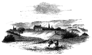
Old Parsonage and Church

Old Parsonage and Church. This view is from the high plain on the right of the block-house, looking north. The building upon the hill across the ravine is the old parsonage, which was immediately built upon the ruins of the one that was burned. On the left I have placed a church in its proper relative position to the parsonage, as indicated by Mr. Lipe. It was about half a mile northwest of the fort. On the right are seen the Mohawk River and Plain, a train of cars in the distance, and the hills that bound the view on the north side of the Mohawk Valley, in the direction of Stone Arabia and Klock’s Field, where two battles were fought in 1780. These will be hereafter noticed.
Galleries
1763-1788 American Revolution PlacesSource
Benson J. Lossing, The Pictorial Field-Book of the Revolution (New York: Harper & Brothers, 1851)I:263
Downloads
2400×1426, 3.3 MiB
1024×608, 168.1 KiB
640×380, 71.6 KiB
320×190, 20.1 KiB