Clipart tagged: ‘gravel layer’
Underground Waters
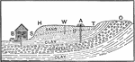
The image shows different layers of clay, gravel, and sand and how underground waters travel through.…
The image shows different layers of clay, gravel, and sand and how underground waters travel through.…