|
|
|
| Maps > Europe > Greece |
Historic and contemporary maps of Greece and Hellas, including political and physical maps, early empires, city plans, and battle plans.
|
The Greek Colonies,
circa 550 BC |
|
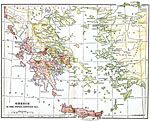
Greece,
Fifth Century B.C. |
|
Battle of Marathon,
September 29, 490 BC |
| First | Previous |
| Maps > Europe > Greece |
Maps ETC is a part of the Educational Technology Clearinghouse
Produced by the Florida Center for Instructional Technology © 2009
College of Education, University of South Florida