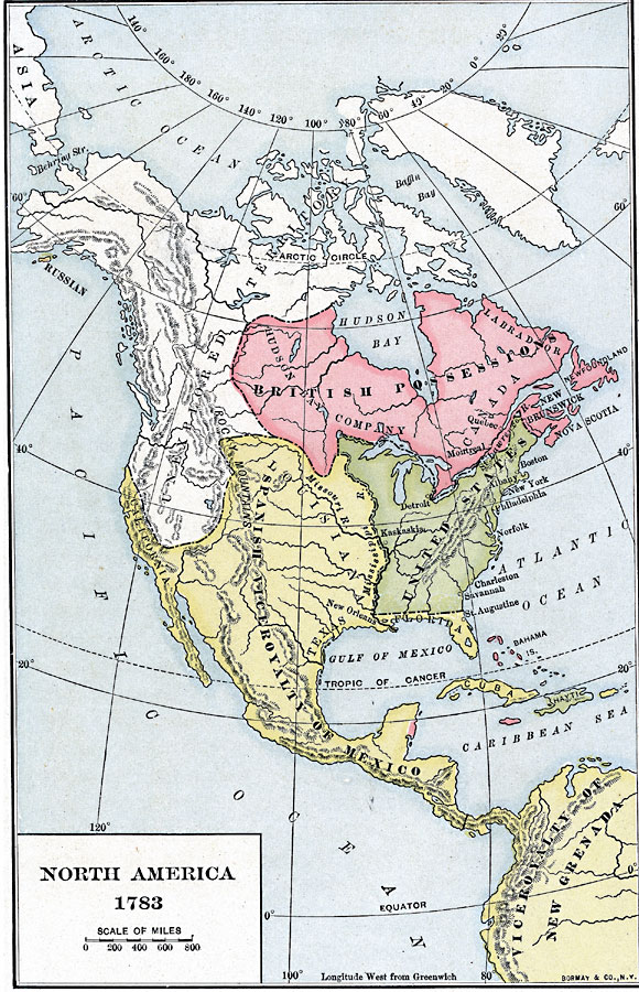
Description: A map of North America, Central America, and northern South America at the end of the American Revolutionary War (1783). The map is color–coded to show the territory of the United States at the time, British possessions in Canada, Russian possession of Kodiak Island in Alaska, and Spanish possessions in the region. The map shows the expanse of unexplored territory in the northwest, the Hudson Bay Company territory, the territories of California, Texas, Louisiana, and Florida under the Spanish Viceroyalty of Mexico, and the northern extent of the Viceroyalty of New Grenada (Columbia and Venezuela) to the Panama Isthmus. The Caribbean island of Jamaica, the Bahamas, and the coast of the Yucatan (British Honduras, or Belize) are shown as British possessions, with Cuba and Puerto Rico to Spain.
Place Names: A Complete Map of North America, Bahamas, �Canada, �Cuba, �Mexico, �United States, �Hait
ISO Topic Categories: boundaries,
inlandWaters,
location,
oceans
Keywords: North America, physical, �political, physical features, country borders, boundaries,
inlandWaters,
location,
oceans, Unknown, 1783
Source: Albert Bushnell Hart, LL.D., The American Nation Vol 10 (New York, NY: Harper and Brothers, 1906) 40
Map Credit: Courtesy the private collection of Roy Winkelman |
|