Maps Site map
  Maps > Globes and Multi-continent > Complete Maps
Site Map  

  Record   51   to   60  of   316

A collection of world and multi-continent maps, including various projections, hemispheric maps, physical and political maps, early known world maps, climate maps, relief maps, ocean current maps, population density and distribution maps, vegetation maps, and economic/resource maps.

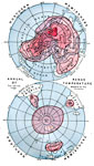
World Annual Range of Temperature, 1888
A map from 1888 showing the northern and southern hemispheres at a polar projection. The map shows the annual range of mean temperature in each hemisphere. The map is color–coded to show areas of temperature ranges measures in degrees Fahrenhei...

Effect of Ocean Current on Temperatures, 1888
A world map from 1888 showing the effect of ocean currents on regional temperatures. The map shows isabnormal lines of temperatures above or below the mean annual air temperature given in degrees Fahrenheit, and is color-coded to show areas abnormall...

Vegetation Regions of the World, 1888
A map from 1888 showing the Vegetation Regions of the world. The map is color–coded to shoe regions of desert, tundra, and ice fields, regions of meadowlands, regions of open forests, regions of dense forest, and regions of very dense forests. ...

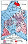
Biological Regions of the World, 1888
A world map from 1888 using a polar projection to separate areas of the world by biological regions that indicate select plants and animals which are characteristic to that particular area. This map divides the world into the South American, North Am...

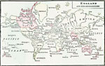
England and Her Dependencies, 1889
A world map from 1889 showing England and the British dependencies at the time. The map is color–coded to show the British possessions, including islands and smaller territories (names underlined in red)....

Map of the Globe, 1890
A map of the world from 1890 showing its continents, islands, mountain ranges, table lands, plains and slopes, rivers, forests, and deserts. This map shows ocean currents with direction of flow, the northern and southern limits of the coral zone, and...

Distribution of Volcanoes and the Regions subject to Earthquakes, 1890
A map of the world from 1890 showing the distribution of volcanoes and the regions subject to earthquakes. This map shows the locations of active volcanoes, extinct volcanoes, central groups of volcanoes (volcanic series of North America, Mexico, Per...

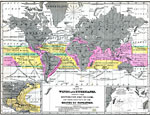
Hydrographical Map of the World, 1890
A Hydrographical map from 1890 showing the oceans and river drainage systems of the globe. The map is color–coded to show the drainage basins of the Atlantic, Pacific, Arctic, and Indian oceans, and inland basins that do not drain to the ocean....

Chart of Ocean Currents, 1890
A map of the world from 1890 charting the Ocean currents and chart of the basin of the Atlantic Ocean. This map is color–coded to show the directions of the warm and cold currents, including the Gulf Stream and branches, Guiana, North Africa an...

Chart of Winds and Hurricanes, 1890
A world chart from 1890 of winds and hurricanes showing their distribution on the globe, and their influence on the routes of navigation. This map shows major sailing routes between San Francisco, New York, New Orleans, Callao, Europe, Calcutta, Cant...

First Previous Next Last


  Maps > Globes and Multi-continent > Complete Maps
Site Map  

Maps ETC is a part of the Educational Technology Clearinghouse
Produced by the Florida Center for Instructional Technology © 2009
College of Education, University of South Florida