Maps Site map
  Maps > Globes and Multi-continent > Complete Maps
Site Map  

  Record   41   to   50  of   316

A collection of world and multi-continent maps, including various projections, hemispheric maps, physical and political maps, early known world maps, climate maps, relief maps, ocean current maps, population density and distribution maps, vegetation maps, and economic/resource maps.

Colonialism, 1885
A map from 1885 of the World showing the European Colonial Possessions at the time....

Important Commercial Products of the Earth, 1888
A world map from 1888 showing regions where primary commercial products are produced. The map also shows the location of the Suez and Panama canals....

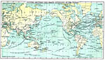
Steamship and Telegraph Routes Between the Grand Divisions of the World, 1888
A world map from 1888 showing principal steamship routes, telegraph (operational and proposed), and submarine telegraph cable routes at the time....

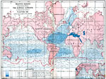
Rain Map of the World, 1888
A Hyetographic or rain map of the world from 1888. This map is shading–coded to show zones of winter rains, summer rains, rains at all seasons, periodical rains, monsoon rains, and rainless regions. The map shows the northern and southern limit...

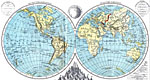
The World in Hemispheres, 1888
The world separated into the Eastern Hemisphere and the Western Hemisphere....

Global Ocean Depths and Land Elevations, 1888
A map of the globe from 1888 showing ocean depths and general land elevations shown on two hemispheres (Pacific Hemisphere and Atlantic–Indian Ocean Hemisphere) defined by the 100th meridian East and the 80th meridian West. The map is color&nda...

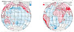
Surface Water Density and Currents, 1888
A world map from 1888 showing the relative density and currents of oceanic surface waters across the globe, and the equatorial limits of floating ice in various parts of the oceans. This map illustrates the effects of salinity (measured in units of s...

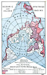
Oceanic and Inland Drainage Basins, 1888
A star–shaped world map from 1888 using a polar projection to show oceanic and inland drainage basins. This map is color–coded to show the land areas that drain into the Atlantic–Arctic, Pacific, and Indian oceans, and inland waters...

Glaciers and Glaciated Regions of the World, 1888
A map from 1888 showing the glaciers and glaciated regions of Eastern and Western spheres. The map is color–coded to show the locations of individual glaciers and regions considered to be glaciated. ...

Regions of Volcanic Action, 1888
A star-shaped world map on a Polar Projection from 1888 showing the regions of volcanic activity on the earth. Regions of surface activity are shown with solid red lines for present or recent activity (crosses show known activity) and open red lines ...

First Previous Next Last


  Maps > Globes and Multi-continent > Complete Maps
Site Map  

Maps ETC is a part of the Educational Technology Clearinghouse
Produced by the Florida Center for Instructional Technology © 2009
College of Education, University of South Florida