Maps Site map
  Maps > Globes & Multi-Continent > Regional Maps >Regional Americas
Site Map  

  Record   31   to   40  of   40

Regional Globes & Multi-Continental maps of the Regional Americas region from the Maps ETC collection. This may include physical and political maps, early history and empires, climate maps, relief maps, vegetation maps, population density and distribution maps, cultural maps, and economic/resource maps.

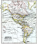
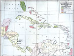
West Indies and Central America, 1910
A map of West Indies and Central America in 1910. The map is color–coded to show the European possessions of Britain, France, Denmark, and the Netherlands in the region at the time, and the possession of Porto Rico by the United States. This ma...

Temperature Zones of North and South America, 1911
A map from 1911 of North and South America showing the climate belts of the region. The map is keyed to show the Tropical belts where mean temperatures are hot (over 68° Fahrenheit) all year, Sub–Tropical belts where mean temperatures over ...

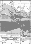
America, Commercial Routes, 1911
This map from 1911 of North and South America displays the steamship routes, their distances and the principal railway routes used though the continents. ...

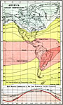
January Mean Temperatures in the Americas, 1911
A map of the Americas from 1911 showing areas of regional mean temperature in January. The map uses isotherm lines to delineate areas of equal mean temperatures, and is color–coded to show temperatures above 70° Fahrenheit in pinks, between...

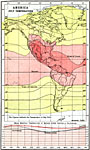
July Mean Temperatures in the Americas, 1911
A map of the Americas from 1911 showing areas of regional mean temperature in July. The map uses isotherm lines to delineate areas of equal mean temperatures, and is color–coded to show temperatures above 70° Fahrenheit in pinks, between 70...

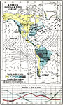
Rainfall and Prevailing Winds for January in the Americas, 1911
A map of the Americas from 1911 showing typical patterns of rainfall and prevailing winds of the region for the month of January. The map is color–coded to show areas where mean rainfall is less than one inch for the month in yellow, between 1&...

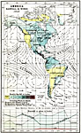
Rainfall and Prevailing Winds for July in the Americas, 1911
A map of the Americas from 1911 showing typical patterns of rainfall and prevailing winds of the region for the month of July. The map is color–coded to show areas where mean rainfall is less than one inch for the month in yellow, between 1&nda...

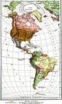
The Americas (Political), 1915
Political map of the Americas showing circa 1915 political boundaries, colonial territories in Central and South America, major cities (including cities with a population over one million), major rail lines, and rivers....

The Caribbean Region, 1917
A map of the Caribbean region showing the protectorates of the United States and territorial claims of the United States, Britain, France, and the Netherlands in 1917. The map is color–coded to show the U.S. territories in green (Porto Rico and...

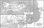
Campaigns of the Spanish-American War, 1919
A map showing three regions of conflict during the Spanish–American War (1898), including the Puerto Rico Campaign (1898–1899), Santiago de Cuba (June–July, 1898), and Manila Bay in the Philippines (May–August, 1898). The maps...

First Previous


  Maps > Globes & Multi-Continent > Regional Maps >Regional Americas
Site Map  

Maps is a part of the Educational Technology Clearinghouse
Produced by the Florida Center for Instructional Technology © 2009
College of Education , University of South Florida