| Maps > United States > Wyoming |
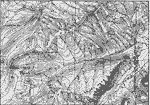 | Absaroka Range, Topography of the Absaroka Range 10 miles east of Yellowstone National Park. |
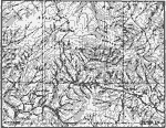 | Encampment District, A map showing mature profiles, long gentle spurs, and rounded summits of the mountains of the Encampment district, south-central Wyoming. |
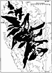 | Glacier Systems of the Bighorns, A map of the glacier systems of the Bighorns at the time of their maximum development. |
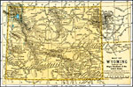 | Wyoming, A map of Wyoming in 1891. |
| Maps > United States > Wyoming |
Maps is a part of the Educational Technology Clearinghouse
Produced by the Florida Center for Instructional Technology © 2007
College of Education, University of South Florida