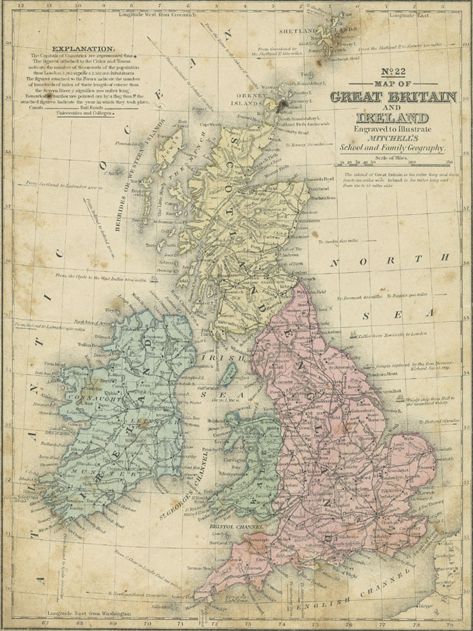
Description: A map of the British Isles from 1852 showing Ireland, Scotland, England, and Wales. This map shows major cities, railroads, canals, universities, rivers, and terrain. Map notations indicate sailing distances measured in miles between the islands and to distant lands, the Irish terminus of the Oceanic telegraph and its length, and shows Longitude from Greenwich at the top of the map and Longitude from Washington at the bottom of the map. "The figures attached to the Cities and Towns indicate the number of thousands of the population thus London 2,362 signifies 2,363,000 inhabitants. The figures attached to Rivers indicate the number of hundreds of miles of their length of course thus the Severn River 2 signifies 200 miles long. Remarkable battles are pointed out by a flag [...] the attached figures indicate the year in which they took place."
Place Names: United Kingdom, Bristol, �Edinborough, �London, �Manchester, �Newcastle, �Plymouth, �Dundee, �Londonderry, �Dublin, Perth, Selkirk, Edinburgh, Lancaster, Manchester, Liverpool, Northampton, Hastings, Dover, �Falmout
ISO Topic Categories: boundaries,
inlandWaters,
location,
oceans,
transportation
Keywords: Map of Great Britain and Ireland, physical, �political, �transportation, �historical, physical features, country borders,
major political subdivisions, railroads,
water routes, other military, boundaries,
inlandWaters,
location,
oceans,
transportation, Unknown, 1852
Source: , Mitchell's School Atlas (Philadelphia, Pennsylvania: E. H. Butler & Co., 1863)
Map Credit: Courtesy the private collection of Roy Winkelman |
|