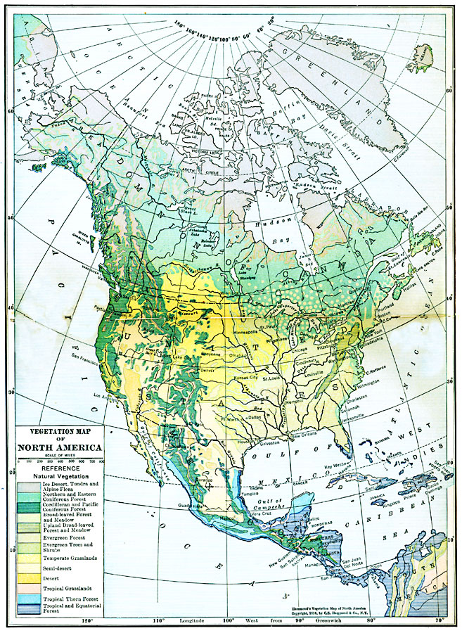
Description: A map from 1916 of North America, Central America, Greenland, and the Caribbean to Puerto Rico showing the general distribution of vegetation types in the region. The map is color–coded to show natural vegetation in areas of ice desert, tundra, and Alpine flora, areas of northern and eastern coniferous forests, cordilleran and Pacific coniferous forests, broad–leaved forest and meadow, upland broad–leaved forest and meadow, evergreen forest, evergreen trees and shrubs, temperate grasslands, semi–deserts, deserts, tropical grasslands, tropical thorn forest, and tropical and equatorial forests.
Place Names: A Complete Map of North America, Bahamas, �Canada, �Cuba, �Mexico, �United States, �Greenland, Central Americ
ISO Topic Categories: boundaries,
inlandWaters,
location,
oceans,
biota
Keywords: Vegetation of North America, physical, �political, �statistical, kBiodiversity, physical features, country borders, vegetation, boundaries,
inlandWaters,
location,
oceans,
biota, Polyconic, 1916
Source: , Hammond's Business Atlas of Economic Geography (New York, NY: C.S. Hammond and Co., 1919) 4-5
Map Credit: Courtesy the private collection of Roy Winkelman |
|