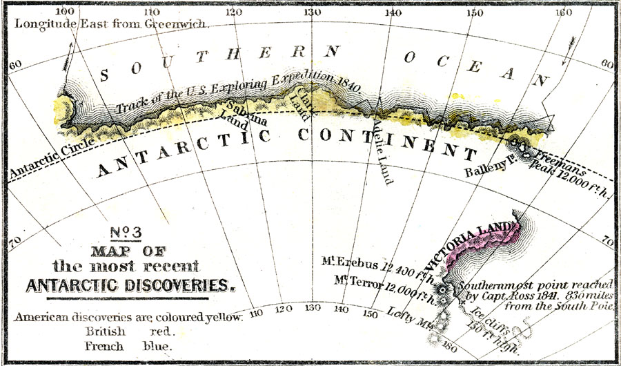
Description: A map from 1863 showing the part of the Antarctic coastline charted by the U. S. Exploring Expedition of 1840 and the southernmost point reached by the expedition of Captain Ross in 1841; which got within 830 miles of the South Pole. The map is color–coded to show the lands explored by the British in red and by the Americans in yellow. The map shows prominent mountain peaks with elevations in feet above sea level, including Mt. Erebus and Mt. Terror, named after the ships of the Ross expedition. "The Antarctic Continent, which lies about 2000 miles south of Australia, was discovered, in 1840, by the American Exploration Expedition, commanded by Capitan Wilkes. About the same distance south of New Zealand is Victoria Land, discovered in 1841, by Capitan Ross, of the British Navy. Both these regions are covered with ice and snow, and are uninhabited." — Mitchell, 1860, p.333.
Place Names: Antarctic Region, sabrina land, �clarie land, �adelie land, �balleny island, �freemans peak, �victoria land, �mount erebus, �mount terror, �lofty mountain
ISO Topic Categories: elevation,
location,
oceans
Keywords: Map of the Most Recent Antarctic Discoveries, physical, �historical, physical features, historical event, elevation,
location,
oceans, Unknown, 1840–1841
Source: , Mitchell's School Atlas (Philadelphia, PA : E. H. Butler & Co., 1863)
Map Credit: Courtesy the private collection of Roy Winkelman |
|