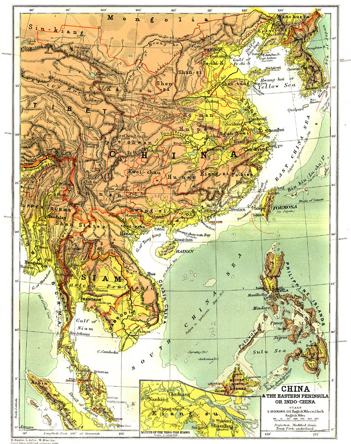
Description: Asia, including China, Korea, Siam, Cambodia, Annam, the Philippine islands, and portions of Mongolia, Tibet, and Burma showing country and province borders current to 1904, major cities, railroad lines, and navigable rivers. Physical features include mountain ranges with elevation measured in feet, major rivers and watersheds, and the 100-fathom line in the offshore waters. Generalized elevations shown as land below 1,000 feet colored light green, and land above 1,000 feet in elevation colored brown. An inset of the mouth of the Yang-tse-Kiang (Yangtze River or Chang Jiang) and Shanghai is included. Interesting typhoon notation indicating that the South China Sea is subject to typhoons from May to November, in the Formosa Strait from August to September, and in the East China Sea from July to September.
Place Names: Eastern Asia, China, �Mongolia, �Philippines, �Thailand, �Cochin China, �Cambodia, �Annam, �Vietnam, �Siam, �Burma, �South China Sea, �Formosa, �Taiwan, �Hong Kong, �Hwang-ho River, �Me-Kong River, �Yang Tse Kiang, �Chung king, �Shangha
ISO Topic Categories: boundaries,
elevation,
inlandWaters,
oceans,
transportation
Keywords: China and the Eastern Peninsula or Indo-China, physical, �political, �transportation, �Mineral Resources, �Modified Conic Projection, �physical features,
topographical, country borders,
major political subdivisions,
local jurisdictions, railroads,
water routes, boundaries,
elevation,
inlandWaters,
oceans,
transportation, Other, 1904
Source: Geo. G. Chisholm and C.H. Leete, eds., Longmans' New School Atlas (New York, NY: Longmans, Green, and Co., 1904) 36
Map Credit: Courtesy the private collection of Roy Winkelman |
|