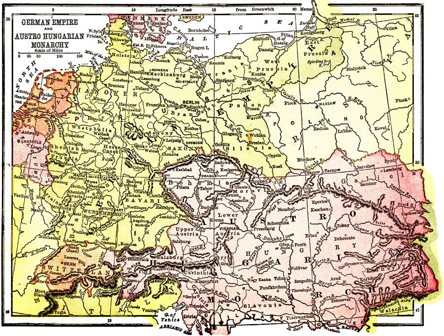
Description: A map from 1904 of Germany and Austria at the time. "Germany - The Government of Germany is a limited monarchy. The German Empire is a confederation of sovereign States, with largely representative governments. Although the Emperor is limited in certain relations, he is given large power in others. By the terms of the Constitution, which bears date April 16, 1871, all the Sates of Germany form an eternal union for the protection of the realm and care of the welfare of the German people. In the King of Prussia, who bears the title of Deutscher Kaiser (German Emperor), is vested the supreme direction of the military and political affairs of the Empire. The Kaiser "represents the Empire internationally," and can declare war, if defensive, and make peace; can enter into treaties with other nations, and can appoint and receive ambassadors. To declare war, of not merely defensive, he must have the consent of the Bundersath, or Federal Council, in which body together with the Reichstag, or Diet of the Realm, are vested the legislative functions of the Empire. The Reichstag represents the German Nation, and its members, 397 in number, are elected by universal suffrage and ballot for terms of three years. The Bundesrath represents the individual States, and its members, numbering 58, are appointed for each session by their respective governments. The Bundesrath and Reichstag meet in annual sessions, convoked by the Emperor. All laws must have a majority of both promulgated by the Chancellor of the Empire." &mdash Wark 1904.
Place Names: Western and Central Europe, Germany, �Poland, �Austro Hungary Monarchy, �Berlin, �Salzburg, �Prague, �Bern, �Hesse Cassel, �Frankfurt, �Switzerland, �Warsaw, �Wurtemberg, �Munich, �Klausenbur
ISO Topic Categories: society
Keywords: German Empire and Austro Hungarian Monarchy, physical, �political, physical features,
topographical, country borders, society, Unknown, 1904
Source: Henry Wark, ed. , Wark's Modern Educator (New York, NY: Henry Wark, 1904) 919
Map Credit: Courtesy the private collection of Roy Winkelman |
|