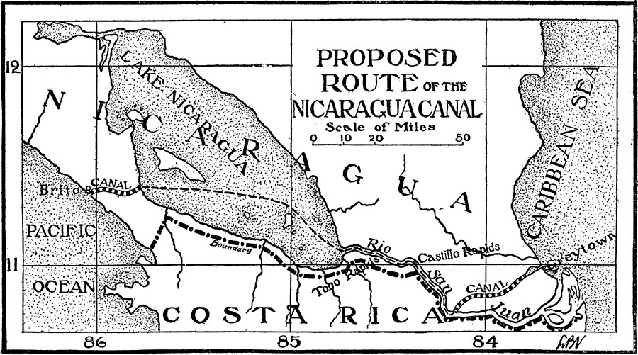
Description: A Map from 1906 of the Isthmus of Nicaragua and the proposed Nicaragua Canal. "Nicaragua Canal, a canal projected across the Isthmus of Nicaragua to connect the Atlantic and Pacific oceans. As originally surveyed, this canal was to extend from Greytown on the Caribbean Sea to Brito on the Pacific. The length was 183.86 miles, of which 70.51 miles was to be through the San Juan River and Lake Nicaragua. The early history of this canal is given under Panama Canal, but there are a few events which apply particularly to the Nicaragua route. In 1849 a concession was granted a company headed by Cornelius Vanderbilt. In 1850 the Clayton-Bulwer treaty was ratified between the United States and Great Britain. This treaty stipulated that neither of the contracting parties should have exclusive control of an isthmian canal. Both nations violated minor provisions of the treaty from time to time, and during the administration of President Arthur the United States negotiated a treaty with Nicaragua providing for the construction and control by this government of an isthmian canal. This treaty had not been ratified in 1885 when President Cleveland came into power, and was withdrawn. In 1889 the Maritime Canal Company was organized, and two years later congress provided for a commission to investigate the canal route and estimate the cost of construction. This commission was followed in 1899 by the Walker commission, whose report in favor of the Nicaragua route aroused general interest in the enterprise, and it seemed very probable that the canal would be constructed according to this recommendation. However, in 1902 before negotiations with Nicaragua were completed, the Panama Canal Company offered to sell their franchises and property to the United States for the valuation placed upon them by the canal commission. This offer was accepted." —Vaughn, 1906.
Place Names: Nicaragua, Brito, �Greytown, �Lake Nicaragua, �Rio San Juan, �Castillo Rapids, �Caribbean Sea,
ISO Topic Categories: boundaries,
inlandWaters,
oceans,
transportation
Keywords: Proposed Route of the Nicaragua Canal, physical, �political, �transportation, �historical, �Canal, �physical features, country borders, water routes, boundaries,
inlandWaters,
oceans,
transportation, Unknown, 1849–1902
Source: L. Brent Vaughn, Hill's Practical Reference Library of General Knowledge Volume III (New York, NY: Dixon, Hanson & Company, 1906)
Map Credit: Courtesy the private collection of Roy Winkelman |
|