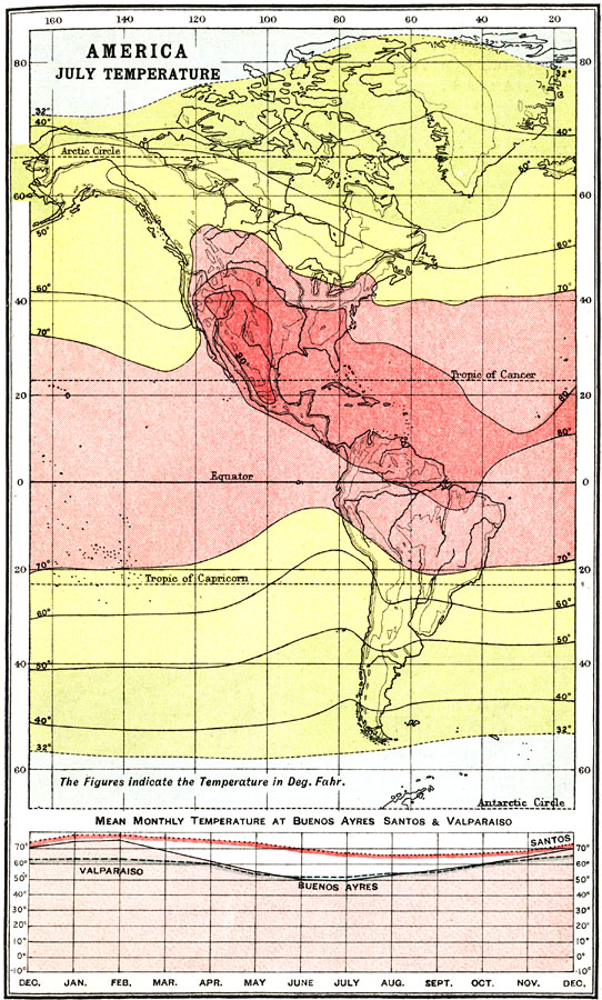
Description: A map of the Americas from 1911 showing areas of regional mean temperature in July. The map uses isotherm lines to delineate areas of equal mean temperatures, and is color–coded to show temperatures above 70° Fahrenheit in pinks, between 70° and 32° Fahrenheit in yellow, and below 32° Fahrenheit in light blue. A chart at the bottom of the map shows the curve of annual mean temperatures by month for the southern hemisphere cities of Buenos Ayres (Argentina), Santos (Brazil), and Valparaiso (Chile).
Place Names: Regional Americas, North America, �South Americ
ISO Topic Categories: meteorological, kClimate, kWorldAmericas
Keywords: July Mean Temperatures in the Americas, meteorological, kClimate, temperature, meteorological, kClimate, kWorldAmericas, Unknown, 1911
Source: Ernest Rhys, Ed., A Literary and Historical Atlas of North & South America (New York, NY: E.P. Dutton & CO., 1911) 29
Map Credit: Courtesy the private collection of Roy Winkelman |
|