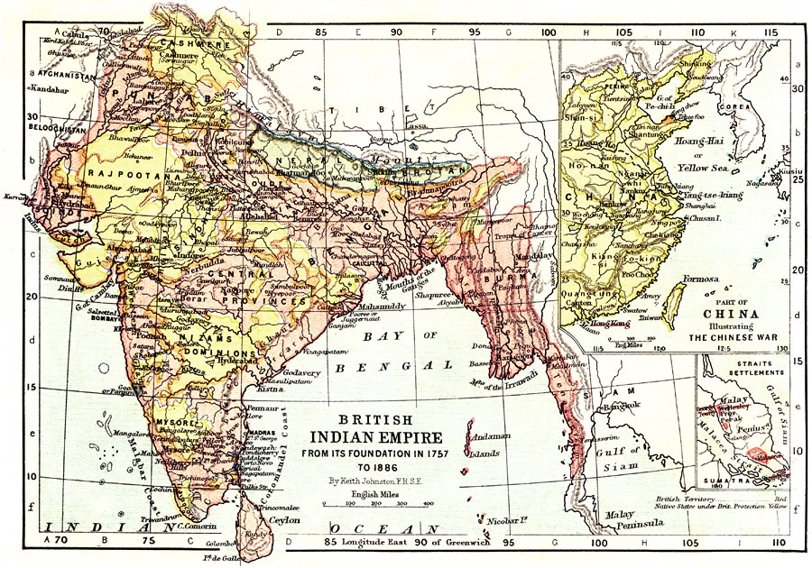
Description: A map of the British Indian Empire from its foundation in 1757 to 1886. This map shows major cities of the time, major river ways, topography and political boundaries. The map is color-coded to show British territories in red and native states under British protection in yellow. The top insert illustrates part of China during the Anglo-Chinese Wars, or Opium Wars, in which China tried to prevent the British from smuggling opium into their country from British India, and Britain coerced the opening of additional trade ports, including the ceding of Hong Kong to Britain. The bottom insert illustrates the British Malacca Straits Settlements of the southern Malay Peninsula. The map scale in English miles.
Place Names: Southern Asia, India, �China, �Tibet, �Cashmere, �Afganistan, �Cabul, �Indian Ocean, �Burma, �Nepal, �Himalaya Mountains, �Siam, �Gulf of Siam, �Mountains of Irrawadi, �Bay of Bengal, �Malabar Coast, �Bombay, �Calcuta, �Ganges River, �Jumna Canal, �Hong Kong, �Perin,
ISO Topic Categories: elevation,
boundaries,
inlandWaters,
oceans,
transportation
Keywords: British Indian Empire from its Foundation in 1757 to 1886. , physical, �political, �transportation, �historical, physical features,
topographical, country borders,
major political subdivisions, water routes, elevation,
boundaries,
inlandWaters,
oceans,
transportation, Unknown, 1757–1886
Source: Keith Johnston, The Half-Crown Atlas of British History (Edinburgh, Scotland: W. & A. K. Johnston, 1871) 28
Map Credit: Courtesy the private collection of Roy Winkelman |
|