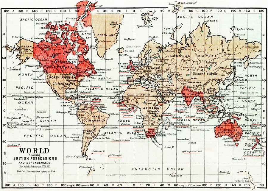
Description: This is a map of The World from 1871 showing British Possessions and Dependencies. This map shows continents, countries, major cities of the time, major river ways and political boundaries. The British possessions are colored red with the names of smaller territories and islands underlined in red. The extent of explored lands in the northern and southern Polar Regions is also shown.
Place Names: A Complete Map of Globes and Multi-continent, Africa, �Asia, �Europe, �North America, �South America, �Australia, �Antartic Ocean, �North Pacific Ocean, �South Pacific Ocean, �Greenland, �United States, �Dominion of Canada, �Hudson Bay, �Alaska, �Arctic Ocean, �Behring Strait, �New York, �Charlest
ISO Topic Categories: boundaries,
inlandWaters,
oceans,
transportation
Keywords: The World showing British Possessions and Dependencies., physical, �political, �transportation, �historical, physical features, country borders,
major political subdivisions, water routes, boundaries,
inlandWaters,
oceans,
transportation, Unknown, 1871
Source: Keith Johnston, The Half-Crown Atlas of British History (Edinburgh, Scotland: W. & A. K. Johnston, 1871) 31
Map Credit: Courtesy the private collection of Roy Winkelman |
|