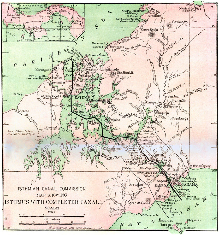
Description: A map from 1913 detailing the Panama Canal Zone and completed canal, with an inset map of the entire country of Panama "The dotted lines show the boundary of the territory known as the Canal Zone, a strip ten miles wide, from deep water in the Atlantic to deep water in the Pacific, and extending five miles on each side of the center line of the Canal, which was purchased by the United States from the Republic of Panama. The heavy line shows the Canal, and the crossed line just above it the relocated Panama Railroad. The cities of Colon and Panama, though included in the limits of the Zone, are reserved to the Republic of Panama. The sanitation of these cities is however, under the control of the United States." — Marshall, 1913.
Place Names: Panama Canal Zone, Santiago, �Colon, �Cristobal, �Panama, �Panama Canal, �Gatun Lake, �Balboa, �Limon Bay, �Bay of Panama, �Gulf of Panama, �Rio Changres, �Changres River, �Rio Boqueron, �Boqueron River, �Miraflores Locks, �Continental Divide, �Cruces, �Canal Zon
ISO Topic Categories: boundaries,
elevation,
inlandWaters,
oceans,
transportation
Keywords: The Isthmus with Completed Canal, physical, �political, �transportation, �historical, physical features, country borders, water routes,
roads, boundaries,
elevation,
inlandWaters,
oceans,
transportation, Unknown, 1913
Source: Logan Marshall, The Story of The Panama Canal (, : L.T. Myers, 1913) 6
Map Credit: Courtesy the private collection of Roy Winkelman |
|