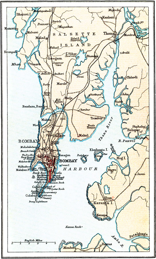
Description: A map from 1912 of India's Bombay (Mumbai) Harbor at the time. The map shows the city of Bombay at the southern point of Bombay Island, which at the time was one of the merged Seven Islands of Mumbai, separated from Salsette and Trombay islands. At the time of this map, the islands of Kolaba, Bombay, Mazagaon, Worli, Parel, and Mahim had been joined together to form one island. The map also shows the islands of Elephanta (Gharapuri) and Butcher, the Thana (Ulhas) River, the coastline at the time, and neighboring cities and towns. Major thoroughfares, roads, railways, docks, government buildings, and historic sites are shown. In 1912, Bombay was growing rapidly and had already reached a million people, becoming India's second largest city at the time.
Place Names: India , Mumbai, �Bomba
ISO Topic Categories: society
Keywords: Old Bombay, physical, �transportation, physical features, railroads, society, Unknown, 1912
Source: Ernest Rhys, Ed., A Literary and Historical Atlas of Asia (New York, NY: E.P. Dutton & CO., 1912) 64
Map Credit: Courtesy the private collection of Roy Winkelman |
|