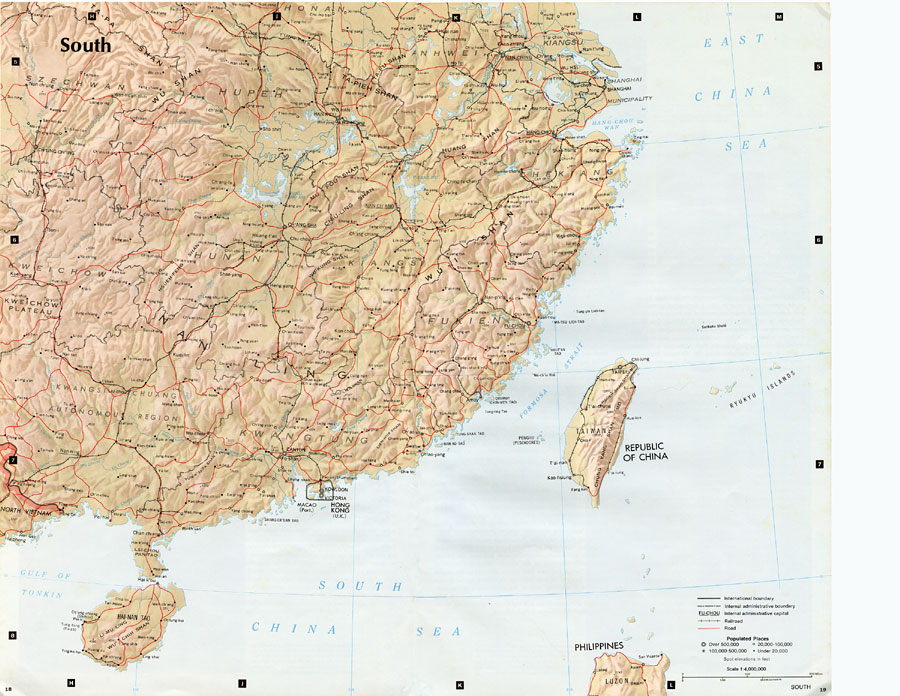
Description: "South China comprises the drainage basins of the middle and lower Yangtze River, the basin of the His Chiang (West River) in Kwangtung and Kwangsi; and the mountainous coastal provinces of Fukien and Chekiang. The division between the North and South, the two most important regions in China, is sharp and distinct in the west, where hills and mountains act as a barrier to movement and form a significant climatic divide. In the east, however, where alluvial plains of the North and the South merge, topographic distinction between the major regions does not exist. Instead, the regional division occurs in a zone characterized by gradually increased precipitation and temperature from north to south, and by the transition in cropping patterns from wheat to rice. The ethnic and linguistic pattern of South China is complex, being the product of repeated migrations and much local isolation. No other part of China, except the Southwest, has such a confusion of ethnic groups and dialects. Until about two thousand year ago South China was inhabited largely by non-Chinese tribes. Newcomers from the north repeatedly pushed the non–Chinese into the more inaccessible areas, and sometimes the subsequent migrants from the north. Even after the region was fully incorporated into China in the third century A.D., newcomers escaping alien oppression or famine in various parts of North China continued to settle in South China, where the hilly and mountainous terrain served to perpetuate and accentuate their ethnic variations. Today Cantonese–speaking people prevail in southern Kwangtung and eastern Kwangsi, and they comprise the largest non–Mandarin–speaking Han Chinese ethnolinguistic group in South China. Widely diverse landscapes, ranging from monotonously flat and densely populated lowlands to sparsely populated hills and mountains, characterize the South. Although, the uplands make up more than 80 percent of the total land surface, the core of South China is the fertile Yangtze Plain — often divided into middle and lower parts. The Yangtze Plain exhibits a coherence not found in other parts of the region: the majority of South China's population is located on or near it; it contains nearly all of the region's major manufacturing centers; and it is the most prosperous part of South China, producing more wealth than the rest of the region combined. The Yangtze Plain is highly irregular in shape and stretches inland some 600 miles before terminating at the steep faced Wu Shan (mountains), guarding the entrance to the Szechwan Basin. About 70 percent of the Yangtze Plain is cultivated; an immense agricultural output is obtained by using intensive production techniques, including multiple cropping. Rice is the major crop and it has long been the primary commercial grain; the other main crop is winter wheat. Although most of the Yangtze Plain is already under cultivation, land reclamation projects are adding materially to the area available for crops. Most of this activity centers on the Plain's marginal lakes — the Tung-t'ing, P'o-yang, and T'ai — and on coastal tracts reclaimed from the sea. The wide, navigable waters of the Yangtze River penetrate deeply into an immensely productive interior, providing an efficient avenue of east-west communication that helps to unite the lowlands and facilitates the exchange of commodities. A number of China's major cities are located along the Yangtze Plain. Wuhan, consisting of the tri-city conurbation of Han–k'ou, Wu–ch'ang, and Han-yang, is an important industrial center that occupies a strategic location, controlling inland waterway, road, and railroad transport over the middle Yangtze Plain. Shanghai, China's largest industrial and commercial metropolis and the country's most important port, lies near the mouth of the lower Yangtze River. It is a city with a wide range of heavy and light industries, and it is especially noted for textiles, iron and steel, and shipbuilding. The coastal zone south of the Yangtze is the only section of China that has a long tradition of interest in seafaring. Rivers here are short and swift, unnavigable, and without extensive floodplains. Each basin constitutes a unit isolated from other basins, except on the seaward side, and agriculture is restricted too small and scattered lowlands. Population pressure on the limited arable land, the presence of numerous protected coves and harbors in the deeply indented coast, and abundant forest resources have combined to give fishing and coastal trading an important place in the traditional life of the region..." — CIA, 1971.
Place Names: China, Fukein, �Taiwan, �Hong Kong, �Cha'ang Sha, �Nan Ling, �Szechwan, �Hang-Cho
ISO Topic Categories: society,
transportation
Keywords: South China, transportation, �physical, physical features,
topographical, roads,
railroads, society,
transportation, Unknown, 1971
Source: Central Intelligence Agency, People's Republic of China Atlas (Washington, DC: U.S. Government Printing Office, 1971) 18
Map Credit: Courtesy the private collection of Roy Winkelman |
|