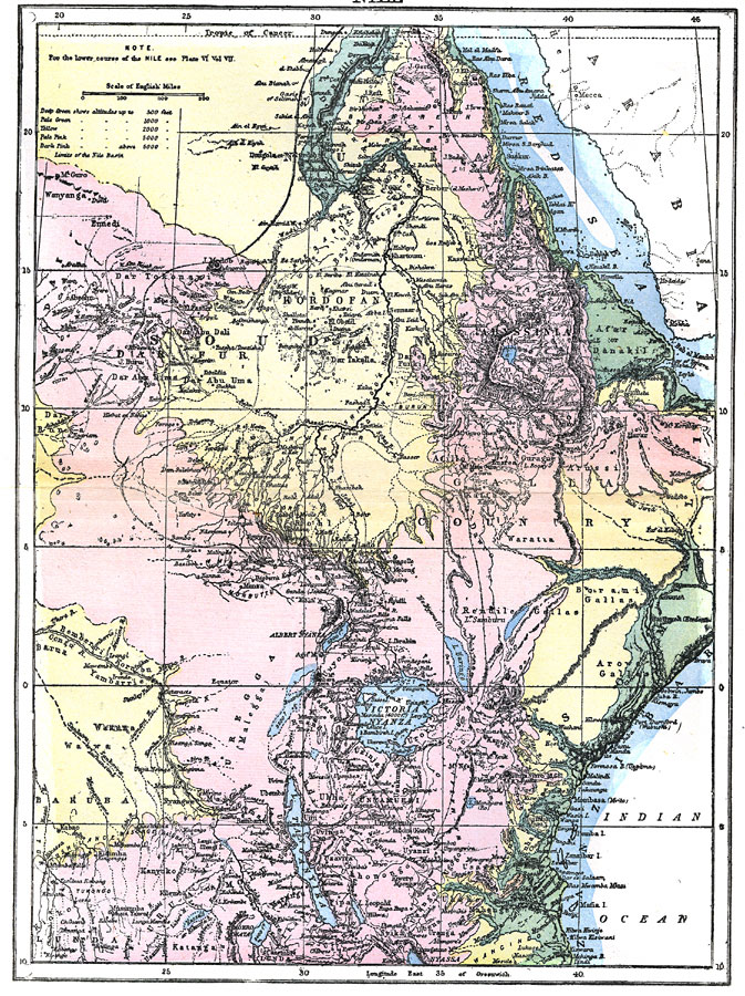
Description: This is a highly detailed map of the Nile River basin from the Tropic of Cancer south to the river's source at Victoria Nyanza (Lake Victoria). This map shows both the Blue Nile and White Nile river systems in 1903. Major cities, trade centers, towns, oases, and caravan routes are shown, as well as tributaries, lakes, mountains, and portions of the Red Sea and Indian Ocean coastlines. Generalized elevations are color coded as below 500 feet in dark green, to 1000 feet in pale green, to 2000 feet in yellow, to 5000 feet in pale pink, and above 6000 feet in dark pink. Native African territories are not clearly defined, however general territories and group names are labeled, such as Nubia, Abyssinia, Galla Country, Sudan, Dar Fur, Kordofan, and Uregga (Malegga).
Place Names: A Regional Map of Africa, Ethiopia, �Egypt, �Somalia, �Sudan, �Nile River, �Soudan, �Uganda, �Tanzania, �Lake Victoria, �Red Sea, �Victoria Nyanza
ISO Topic Categories: boundaries,
inlandWaters,
oceans
Keywords: Nile, physical, �political, kAfricanNativeStates, physical features,
topographical, country borders, boundaries,
inlandWaters,
oceans, Unknown,1903
Source: Day Otis Kellogg, Encyclopædia Britannica Vol. XVII (New York, NY: Werner Company, 1903) 504
Map Credit: Courtesy the private collection of Roy Winkelman |
|