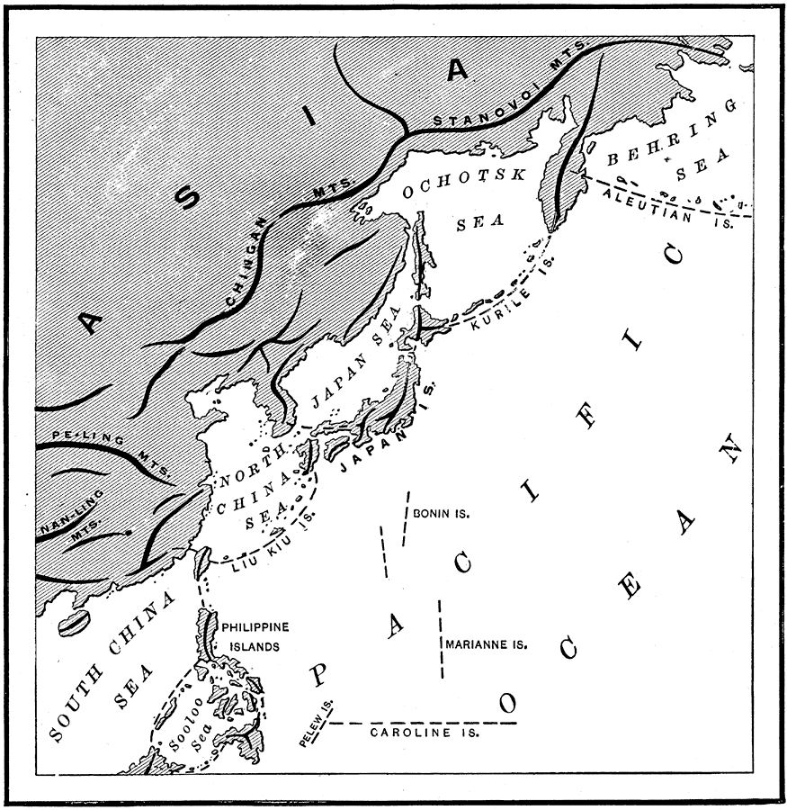
Description: A map from 1890 of the Asiatic Island chains from the Aleutian Islands south to the Philippines and Caroline Islands. Mountain ranges are shown by heavy black lines, and the map shows the mainland mountain ranges of Stanovoi, Chingan, Pe–Ling, and Nan–Ling. The Behring Sea, Ochotsk (Okhotsk) Sea, Japan Sea, North and South China seas, Sooloo Sea, and the Pacific Ocean are shown, as well as the Aleutian, Kurile, Japan, Liu Kiu, Bonin, Philippine, Marianne, Pelew, and Caroline island groups. "The eastern side of this continent is accompanied by a series of curved island-chains, the summits of submarine mountains clearly belonging to the system of the Asiatic elevations. They extend from northeast to southwest. a. The Kurile Islands, a continuation of the mountains which extend from north to south through Kamchatka. b. The Japanese Islands, curving from Saghalin off the coast of Siberia to the Peninsula of Corea [sic]. c. The Liu Kiu Islands, forming a curve from Corea [sic] to Formosa. d. The Philippine Islands, forming two chains diverging towards the south. The eastern range terminates with the elevations of Celebes and Borneo, it should be remembered, belong to the group of the larger Molucca Islands. In the annexed figures the trend, or direction, of these chains is indicated by dotted lines." — Brewer, 1890, p.41
Place Names: Eastern Asia, China, �Japan, �Philippines, �North Korea, �South Korea, �Korea, �Sooloo Sea, �Sulu Sea, �North China Sea, �Japan Sea, �Ochotsk Sea, �Sea of Japan, �Okhotsk Sea, �Behring Sea, �Bering Sea, �Aleutian Islands,
ISO Topic Categories: boundaries
Keywords: Asiatic Island Chains, physical, �island formation, �physical features, boundaries, Unknown, 1890
Source: William H. Brewer Ph.,D., Warren's New Physical Geography (Philadelphia, PA: Cowperthwait and Company, 1890) 41
Map Credit: Courtesy the private collection of Roy Winkelman |
|