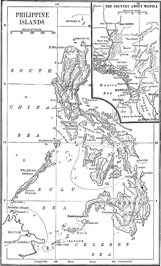
Description: A map from 1898 of the Philippine Islands, showing the major island names, cities and ports, terrain, smaller islands, and coastal features. There is an enlarged insert of the area around Manila, the chief city. "These islands, which have been chiefly formed by volcanic action, lie in the great chain of upheaval between Kamchatka and the Sunda Islands. Luzon, the largest, is about 480 miles long, and has an area of a little more than 41,000 square miles. Mindanao, in the south, is the second in size. The Sulu Islands, stretching in a chain southwestwardly almost to Borneo, belong also to the Philippine group. The islands composing the middle part of the group are known as the Visayas. The length of the entire group, from the most northern point to the most southern, is more than 1,000 miles." As of 1898, "the interior of the larger islands [had] never been explored, and many of the smaller islands [were] practically unknown...There are three seasons, the cold, the wet, and the hot; but even in the cold season the mercury seldom falls below 70°. The annual rainfall at Manila is about 75 inches. The wet season begins in July and last still November...In the forests are vast quantities of valuable timber and tropical trees peculiar to these islands. Fruits are very abundant. The finest sugar comes from Panay and the other islands in the center of the group. The climate is favorable for the production of coffee, tobacco, cotton, and spices. The plant from which Manila hemp is produced grows only in these islands. Valuable minerals, as gold, copper, iron, lead, and coal (lignite), are known to exist in certain localities." — Redway, 1898.
Place Names: Philippines, Manila, �Batangas, �Puerto Princesa, �South China Sea, �Sulu Sea, �Celebes Sea, �Manila Bay, �San Isidro, �Bacolor, �Malolos, �Bulacan, �Morong, �Santa Cruz, �Luzon, �Mindanao, �Balabac Strait, �Mindoro Strait, �Engano, �Vigan, �San Bernardino Srait, �
ISO Topic Categories: boundaries,
elevation,
inlandWaters,
oceans,
transportation
Keywords: Philippine Islands, physical, �political, �transportation, �historical, physical features,
topographical, country borders, water routes, boundaries,
elevation,
inlandWaters,
oceans,
transportation, Unknown, 1898
Source: Jacques W. Redway and Russell Hinman, Natural Advanced Geography (New York, NY: American Book Company , 1898) 4
Map Credit: Courtesy the private collection of Roy Winkelman |
|
