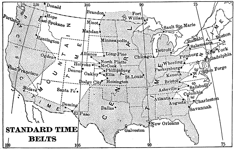
Description: A map from 1898 showing the Standard Time Belts in the contiguous 48 states as they were then established. "The main body of our country is so broad from east to west that more than three hours are required for rotation to carry it past the sun. Hence, if we are told that a railroad train starts ‘at noon,’ we cannot be sure of its time of starting, because it is noon at different places in our country for more than three hours after that time occurs on the Atlantic coast. To avoid mistakes, delays, and confusion, the railroad companies of the country have adopted the times of the meridians of 75°, 90°, 105°, and 120°, as the standards by which to run their trains. [...] Each railroad company suits its own convenience as to the point on its line where a change of standard time is made. [...] In the extreme southwest, Mountain time is not used, but the change is made from Central time directly to Pacific time." — Redway, 1898, p.61.
Place Names: A Complete Map of the United States, Boston, �Chicago, �New Orleans, �New York, �time zone
ISO Topic Categories: society
Keywords: Standard Time Belts, time zones, �time belts, �historical, society, Unknown,1898
Source: Jacques W. Redway and Russell Hinman, Natural Advanced Geography (New York, NY: American Book Company , 1898) 61
Map Credit: Courtesy the private collection of Roy Winkelman |
|