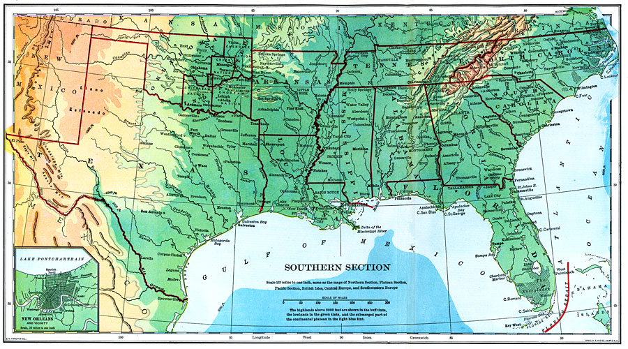
Description: The southern section of the United States as of 1898. "Long, hot summers and short, temperate winters prevail over nearly the whole of this section. Although snow sometimes falls in all the states, it soon melts. Over nearly the whole section the rainfall is abundant for purposes of farming, It is only in the extreme west that serious droughts occur. The surface for a hundred miles or more from the coast is quite flat, then occur the low Piedmont hills in the east and the gently rolling plains in the west. The surface is rugged only near the Appalachian and Ozark ridges and near the mountains in the extreme west. The soil, though sandy near the coast, is generally very fertile. Agriculture is the great industry, and cotton is by far the most important crop. More than one fourth of the farm land is devoted to the cultivation of this fiber, and this region is the world's greatest cotton-producing region...After cotton, corn is the most extensive crop of the section, particularly in the northern part, where wheat and tobacco are also grown, while from the southern part come all rice and cane sugar produced in this country, and many pf the oranges. This section also produces most of the peaches and sweet potatoes raised in the United States. In the northern part, where grain is grown, many hogs and fine horses are raised, and in the western part, many cattle and sheep...In the northern section, especially in the valleys of the Appalachian and Ozark Mountains, are our most extensive forests of oak, hickory,, ash, poplar, and cotton-wood. The forests of the coast plain are composed chiefly of yellow or southern pine, which is a much harder wood than the white pine of the North...The most extensive [coal mines] are in the Appalachian and Ozark regions. Near the southern end of the Appalachians, so much iron ore is obtained that it has become the greatest iron-mining region in the country, after tge Lake Superior region...The coast of nearly the whole section is fringed with barrier beaches, and many of the inlets between them have narrow, crooked channels, often obstructed by shifting bars. Hence foreign commerce is not so great as on our northeastern coast, though much cotton and some coal and lumber are exported, and there is an active coasting trade in small vessels." &mdashRedway, 1898.
Place Names: Southern States, New Orleans, �Miami, �Houston, �Tallahassee, �Tampa, �Montgomery, �Atlanta, �Columbia, �Raleigh, �Jackson, �Baton Rouge, �Mississippi River, �Little Rock, �Gouthrie, �Santa Fe, �Rio Grande, �Austin, �Choctaw Nation, �Chickasaw Nation, �Creek Nation, �C
ISO Topic Categories: boundaries,
elevation,
inlandWaters,
oceans,
utilitiesCommunication
Keywords: Southern Section of the United States, historical, �physical, �political, �transportation, physical features,
topographical, major political subdivisions,
country borders, water routes, boundaries,
elevation,
inlandWaters,
oceans,
utilitiesCommunication, Unknown,1898
Source: Jacques W. Redway and Russell Hinman, Natural Advanced Geography (New York, NY: American Book Company , 1898) 78-79
Map Credit: Courtesy the private collection of Roy Winkelman |
|