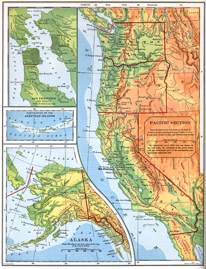
Description: The Pacific Section of the United States as of 1898. "The Sierra Nevada and the Cascade Mountains are about as high as the Rocky Mountains, but they seem much higher and grander when viewed from the west, because they rise frm lowland valleys instead of from a high plateau...West of the Sierra Nevada and Cascade Mountains there is comparatively little difference between summer and winter temperatures. East of the mountains, however, the climate is much drier, with hotter summers and colder winters. The rainfall west of the mountains occurs most during the winter months...Agriculture is the principal industry in the valleys west of the great mountain ranges, and wheat, grapes, and other fruit are the most important crops. Much wheat is also raised east of the Cascade Mountains in the Columbia valley...In the drier regions, and on the mountain slopes, cattle and sheep raising are important occupations...Gold mining is extensively carried on in the west slope of the Sierra Nevada, which is one of the richest golf fields on the world...Most of the railroads which enter this section...are the great transcontinental lines which cross the Rocky Mountain highland from the Mississippi valley...The coast is closely bordered by the Coast Ranges, and has few bays and harbors. The ranges are broken in the north, however, by Puget Sound and the Columbia River, and in the central part by the Bay of San Francisco. These indentations afford safe harborage to the largest vessels, and from them almost all the foreign commerce of our Pacific coast is carried on." &mdashRedway, 1898.
Place Names: Pacific States, Los Angeles, �San Diego, �Seattle, �Salem, �Portland, �San Francisco, �San Francisco Bay, �Pacific Ocean, �Carson City, �Boise, �Olympia, �Sacramento, �Mexico, �Canada, �Pacific States, �California, �Washington State, �West Coas
ISO Topic Categories: boundaries,
elevation,
inlandWaters,
oceans,
transportation
Keywords: Pacific Section of the United States, physical, �political, �transportation, �historical, physical features,
topographical, country borders,
major political subdivisions, water routes, boundaries,
elevation,
inlandWaters,
oceans,
transportation, Unknown,1898
Source: Jacques W. Redway and Russell Hinman, Natural Advanced Geography (New York, NY: American Book Company , 1898) 88
Map Credit: Courtesy the private collection of Roy Winkelman |
|