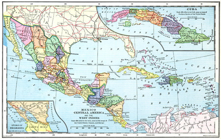
Description: A map from 1898 of Mexico, Central America and the West Indies. The map includes an inset map of Cuba and the Isthmus of Nicaragua. "The surface of the Rocky Mountain highland in Mexico is quite similar to that of the great plateau region in the United States. It is bordered on the east and west by mountain ranges corresponding to the Rocky and the Cascade Mountains, but the western Mexican range is much higher and more continuous than the eastern. In the north the plateau is about three fourths of a mile high, but it rises gradually to twice that elevation in the south...Owing to the tropical position of Mexico there is little difference between the temperature of summer and of winter; but because of the variation in elevation there is a great difference in the temperature of different regions. The lowlands are always hot; the plateau is always temperate, and the mountain region, more than 1½ miles high, is cool or cold, some of the higher peaks being always snow-clad. The seasons of Mexico are the wet and the dry. Nearly all the rain falls during the summer months...Plants and animals of both the North and the South American regions are found in Mexico...The plateau of Central America is neither so broad nor so high as that of Mexico. The mountain range near the Pacific coast contains the high cones of many active volcanoes, and the earthquakes are more frequent and severe than in Mexico. The climate is similar to that of southern Mexico, but warmer and with heavier rainfall on the north coast...The countries of Central America are more uniformly forest-covered than is Mexico, but in the interior there are large tracts of grass land. Sugar, coffee, cacao beans or chocolate nuts, tropical fruits, and cabinet and dye woods are exported...The islands of the West Indies are partly volcanic and partly of coral formation; they are subject to earthquakes, and are surrounded by coral reefs. Most of the Lesser Antilles are high, and consist wholly or mostly of volcanic rock. The islands of the Greater Antilles have broad lowland coast regions; Cuba is mainly lowland. The Bahamas are all low islands composed of coral limestone and broken shell, and the hills on these islands are mostly wind-formed. All the islands of the West Indies together contain about as much land as the state of Wyoming, nearly half of this being the single island of Cuba, which is nearly as large as the state of New York...The larger islands are forest-covered. The vegetation varies, as in Mexico and Central America, with the altitude. The most valuable product of the of the islands is sugar cane." — Redway, 1898.
Place Names: A Regional Map of North America, Bahamas, �Cuba, �Mexico, �Central America, �Guatemala, �Belize, �Honduras, �El Salvador, �Nicaragua, �Coasta Rica, �Panama, �Puerto Rico, �Haiti, �West Indies, �Greater Antilles, �Jamaica, �Gulf of Mexico, �Bahama Islands, �Atlantic Ocean, �Pacific Oce
ISO Topic Categories: boundaries,
elevation,
inlandWaters,
planningCadastre,
transportation
Keywords: Mexico, Central America, and the West Indies, political, �physical, �transportation, �historical, kCaribbean, kCentralAmerica, physical features,
topographical, country borders,
major political subdivisions, water routes, boundaries,
elevation,
inlandWaters,
planningCadastre,
transportation, 1898
Source: Jacques W. Redway and Russell Hinman, Natural Advanced Geography (New York, NY: American Book Company , 1898) 96
Map Credit: Courtesy the private collection of Roy Winkelman |
|