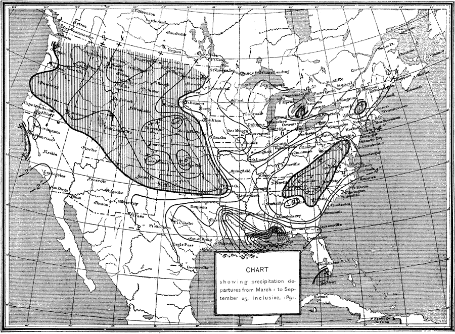
Description: A map from the United States Department of Agriculture showing precipitation departures in 1891. "The seasonal conditions of rainfall from March 1 to September 25 throughout the United States, or during the growing period of the present year. From this chart it will be seen that more than the usual amount of rain occurred from the Indian Territory and northern Texas northward over the west slope of the Missouri Valley, including the west half of South Dakota and the greater portions of North Dakota. This region of excessive rain extends to the Pacific coast, over Oregon and the greater portion of Washington. Within the limit of the shaded portion of the chart light lines indicating areas over which the rainfall ranged from 2 to 6 inches in excess of the usual amount, and the time of the occurrence of this rainfall, will be found in the weekly record of the stations, as given in the tabular statement. Small areas of excessive rainfall occurred over the eastern portion of the United States, as shown on the charts, while throughout the central valleys, including the greater portion of the cotton, corn, and wheat regions, the rainfall was less than usual. While the deficiency was slight and ranged only from 2 to 6 inches below the average of previous years in the corn and wheat States of the central valleys and in the northern portion of the cotton region, there was a marked deficiency in the lower Mississippi Valley along the Gulf coast, where the rainfall was 8 to 20 inches less than usual, the region of greatest drought including the sugar and rice regions of Louisiana. On the Pacific coast, the rainfall was generally in excess in Oregon and Washington, while over the greater portion of California it was from 1 to 2 inches less than usual." — Report of the Secretary of Agriculture, 1891.
Place Names: Meteorology, Boston, �Chicago, �Houston, �Los Angeles, �Miami, �New Orleans, �New York, �San Diego, �Seattle, �Washington D.C., �precipitatio
ISO Topic Categories: climatologyMeteorologyAtmosphere,
boundaries,
inlandWaters
Keywords: Precipitation Chart, physical, �political, �meteorological, �precipitation, kClimate, physical features, country borders,
major political subdivisions, rainfall, climatologyMeteorologyAtmosphere,
boundaries,
inlandWaters, Unknown,March 1, 1891–September 25, 1891
Source: , Report of the Secretary of Agriculturre - 1891 (Washington, DC: Government Printing Office, 1892) 586
Map Credit: Courtesy the private collection of Roy Winkelman |
|