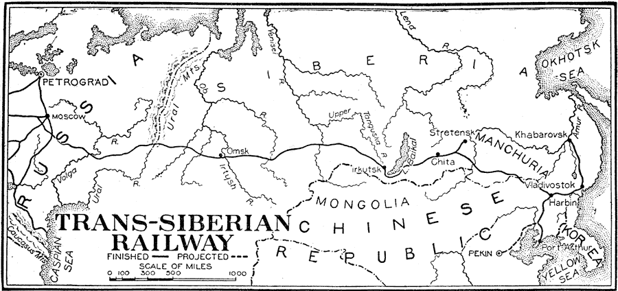
Description: A map of the Trans–Siberian Railway system from Petrograd (St. Petersburg) to Vladivostok on the Pacific. The map shows the en route cities of Moscow, Omsk, Irkutsk, Chita, and Harbin, with spur routes to Stretensk, Khabarovsk, and Port Arthur in China. The map shows the connection of this system to the rail network in Europe and to the Caspian Sea, and the proposed railway from Pekin (Beijing) to the existing line between Harbin and Port Arthur. "Trans-Siberian railway, a line of railway connecting the transportation systems of Russia with the port of Vladivostok, on the Sea of Japan, until 1918 the most eastern outpost of the great Russian empire. The Trans-Siberian Railway was the outgrowth of a number of projected plans for establishing means of communication between the Russian possessions in Europe and Asia. Its construction was approved by an imperial rescript given by given by the Czarovitch, later Nicholas II, March 17, 1891. Work was commenced immediately, and the main line was completed in 1905. The line as originally planned was divided into six sections, as follows: Western Siberian, from Chelyabinsk to Omsk, 878 miles; Central Siberian, from Omsk to Irkutsk, 1,134 miles; Trans-Baikal, from Myosava to Stretensk, 685 miles; Amur, from Stretensk to Khabarovsk, 1373 miles; Usuri, from Khabarovsk to Vladivostok, 474 miles. The Amur section was later replaced by a line running farther south through Manchuria, known as the Manchurian Section. This section extends 952 miles from Nagaden, where it leaves the main line; it also has a southern branch extending to Port Arthur, thus giving the railway access to a port which is free from ice the entire year. The distance from Chelyabinsk to Vladivostok is 3,961 miles, and to Port Arthur, 4,238 miles. The entire system has 6,800 miles of road." — Foster, 1921.
Place Names: Northern Asia, Russia, �Chinese Republic, �Siberia, �Korea,�Chin
ISO Topic Categories: transportation
Keywords: Trans-Siberian Railway, physical, �transportation, physical features, railroads, transportation, Unknown,1891–1918
Source: Ellsworth D. Foster, ed., The American Educator Vol. 8 (Chicago, IL: Ralph Durham Company, 1921) 3609
Map Credit: Courtesy the private collection of Roy Winkelman |
|