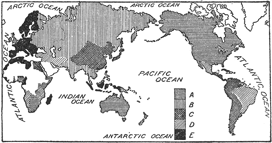
Description: This is a global map from 1921 showing the commanding position of the English system for weights and measures. The map is shade–coded to show the areas where the English Units (or Imperial Units) are predominately used (A), areas where Metric Units are either compulsory or predominately used (E), and gradations of use between the two systems. The areas shown by (C) and (D) indicate areas where older systems are used, such as China and Japan, Mexico (Spanish Units) and Asia Minor (Turkish Units)."It reveals that the English system, established in 1266, for economic currency still prevails throughout the world." — Foster, 1921
Place Names: A Complete Map of Globes and Multi-continent, Africa, �Asia, �Australia, �Europe, �North America, �South America, �Arctic Ocean, �Indian Ocean, �Atlantic Ocean, �Pacific Ocean, �Antarctic Ocean
ISO Topic Categories: boundaries,
economy,
society
Keywords: The World's Weights and Measures, statistical, �weights, �measures, �currency, kEconomic, economic, boundaries,
economy,
society, Unknown,1921
Source: Ellsworth D. Foster ed., The American Educator Vol. 8 (Chicago, IL: Ralph Durham Company, 1921) 3843
Map Credit: Courtesy the private collection of Roy Winkelman |
|