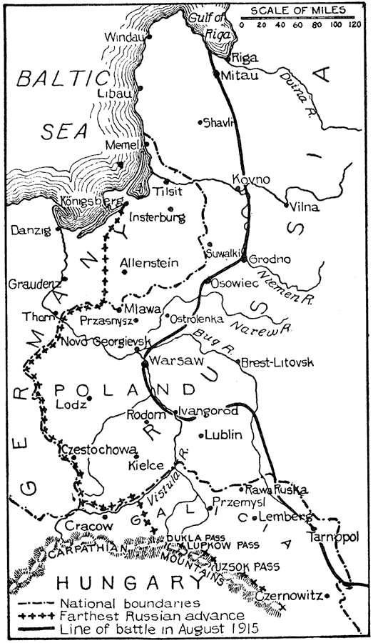
Description: This is a map showing the boundaries and battles in the eastern campaign of World War I from 1914 to 1915. "In the east Poland became the great battlefield, for the chief objective of the Russians was the conquest of Galicia, or Austrian Poland, while the Germans sought the conquest of Russian Poland. During the first month of war the Russians mobilized with unexpected rapidity, advanced in force through East Prussia, and for a few days threatened serious consequences. On September 1 the terrible rout at Tannenberg ended the danger from this source, and made Von Hindenburg one of the great figures of the war. Gradually the Russians were forced back to Neimen, where they took hold and later carried their line back to the German frontier. Here a deadlock arose like that in the west. Meanwhile, in Galicia, Russia was winning tremendous success. Tarnopol and Lemberg fell, Przemysl was besieged, and by October 1 the Austrians were driven back to within 50 miles of Cracow. At this point the Germans launched a strong offensive movement against the Russian center, which was driven back over 100 miles to the permanent defenses of Ivangorod and Novo Georgievsk. This retreat of the center compelled the Russian left to retreat in Galicia, but the relief to the Austrians was only temporary. The German advance was only seven miles from Warsaw when the Russians, by a threatened flanking movement, compelled a retreat to the German border. Once again in December, January and February, the Germans slowly advanced on Warsaw, but were unable to take it. In East Prussia the Russians advanced in force in February, but after the ten-days' battle of the Mazurian Lakes they were compelled to retire. In Galicia the Russians made themselves masters, finally took Przemysl on March 22, 1915, seized all the passes of the Carpathian Mountains, and were ready to advance in force across the plains of Hungary. Just as an invasion of Hungary seemed certain a combined German and Austrian army led by Von Mackensen routed the Russians and drove them out of Galicia, forcing them back to the position they held at the beginning of the war. By the first of August the Germans were again at the gates of Warsaw and on the 4th the city was taken. By this campaign the central powers regained the lost territory and rendered a new Russian offensive impossible for several months." — Foster, 1921.
Place Names: Eastern Europe, Germany, �Poland, �Hungary, �Russia, �Galicia, �Baltic Sea, �Gulf of Riga, �Windau, �Libau, �Shavlr, �Duina River, �Kovno, �Vilna, �Mitau, �Memel, �Tilsit, �Konigsberg, �Insterburg, �Niemen River, �Narew River, �Suwalki, �Grodno, �Osowiec, �Ostrolenka,
ISO Topic Categories: boundaries,
society,
inlandWaters
Keywords: World War I: A Year of War in the East, physical, �political, �historical, kWWI, physical features, country borders,
major political subdivisions, WWI, boundaries,
society,
inlandWaters, Unknown,1914–1915
Source: Ellsworth D. Foster ed., The American Educator Vol. 8 (Chicago, IL: Ralph Durham Company, 1921) 3918
Map Credit: Courtesy the private collection of Roy Winkelman |
|