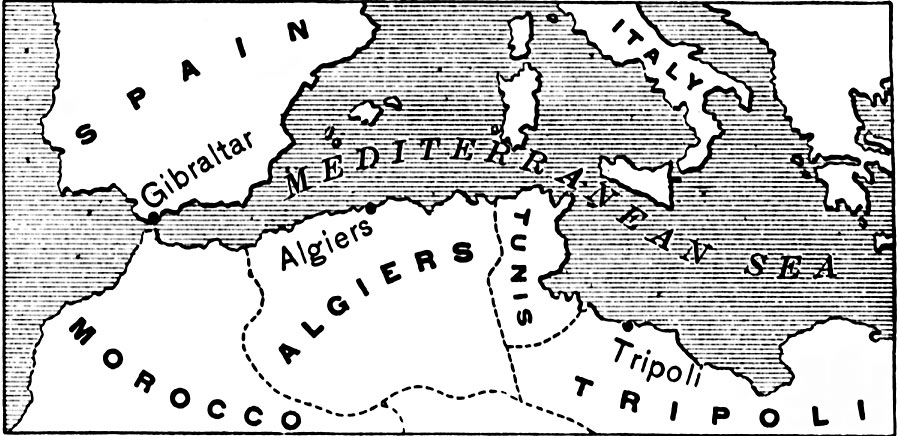
Description: A sketch map of the Mediterranean region showing the North African countries of Morocco, Algiers, Tunis, and Tripoli at the time of the Barbary Coast Wars (1801–1805 and 1815) between the United State and Barbary States. "During Jefferson's time, the United States was at peace with all the great powers. The wars raging in Europe had injured the commerce of England and France. Foreign merchants, whose countries were at war, preferred to send goods in American vessels, to prevent their being captured by the enemy. In this way American commerce became very prosperous." (Eggleston, 1898) The Mediterranean trade routes between the Strait of Gibraltar and the Suez Isthmus were under threat of piracy and the demand of tributes from the Barbary States, which were nominally under Turkish rule as Ottoman Empire regencies. The refusal by the United States to pay increasingly high tributes to the regencies led to the wars, which in turn marked the decline and eventual end of the age of piracy in the region.
Place Names: Regional Mediterranean, Europe, �Afric
ISO Topic Categories: physical, �political, �historical, �barbary pirates, kWorldMedSea
Keywords: The Mediterranean Sea, physical, �political, �historical, �barbary pirates, physical features, country borders, other military, physical, �political, �historical, �barbary pirates, kWorldMedSea, Unknown, 1801–1815
Source: Edward Eggleston, The Household History of the United States and Its People (New York, NY: D. Appleton and Company, 1898) 229
Map Credit: Courtesy the private collection of Roy Winkelman |
|