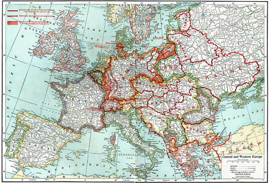
Description: A map of Central and Western Europe after the Treaty of Versailles at the end of WWI. The map shows the lack of defined borders before they were finalized in treaty negotiations, and includes railroads, canals, shipping routes, major cities and capitals, and the country boundaries established by the Treaties of Versailles, proposed boundaries of new states, sections of which sovereignty is to be established by plebiscite, and the territory to be occupied by allied troops for 15 years. This map also includes the areas of fortification to be dismantled by the Germans, the Alsace–Lorraine territory, the neutral territory between the Aegean Sea and the Bosporus Straits, and shows Geneva as the Seat of the League of Nations.
Place Names: Western and Central Europe, Ireland, �England, �Scotland, �Wales, �Spain, �Portugal, �France, �Italy, �Switzerland, �Germany, �Belgium, �Netherlands, �Austria, �Serbia, �Albania, �Greece, �Bulgaria, �Roumania, �Turkey, �Romania, �Norway, �Jutland, �Poland, �Sweden, �United Kingdo
ISO Topic Categories: boundaries,
inlandWaters,
location,
oceans,
transportation
Keywords: Central and Western Europe, Post WWI, physical, �political, �transportation, �historical, �map of europe post WWI, directly after WWI, borders undecided, pre-treaty, physical features, country borders, railroads,
water routes, WWI, boundaries,
inlandWaters,
location,
oceans,
transportation, Unknown, 1920
Source: , Leslie's New World Atlas (New York City, NY: Leslie-Judge Company, 1920) 10-11
Map Credit: Courtesy the private collection of Roy Winkelman |
|