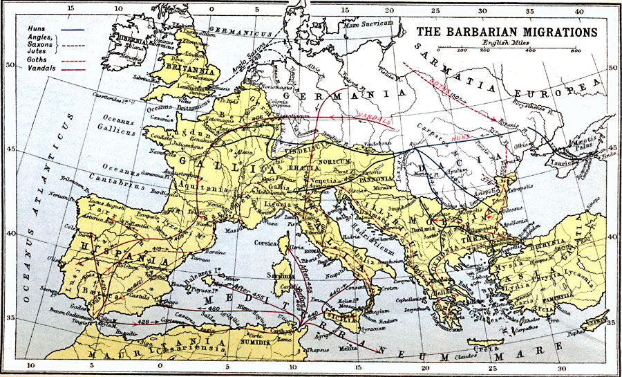
Description: A map showing the Barbarian migrations and the countries to which they dispersed including the general flows of the Huns (AD 441–452), the Angles, Saxons, and Jutes (AD 449), the Goths (circa AD 150 to 419), and the Vandals (AD 404–468). This map shows important cities of the period, rivers, and bodies of water with Latin names, and the territories of Sarmatia Europea, Dacia, Germania, Hibernia, the Roman territories of Britannia, Belgica, Lugdun, Gallia, Aquitania, Hispania, Tarra, Lusitania, Batica, Narbonensis, Vindelicia, Noricum, Venetia, Rhætia, Liguria, Gallia Cisalpina, Italia, Pannonia, Illyricum, Moesia, Thracia, Macedonia, Epirus, Hellas, Achaia, Creta, the Asian territories of Bithynia, Galatia, Mysia, Lydia, Caria, Phrygia, Lycaonia, Pamphylia, Lycia, and Cyprus, and the African territories of Numida and Mauritania.
Place Names: Western and Central Europe, Africa, �Asia, �Europ
ISO Topic Categories: inlandWaters,
location,
oceans
Keywords: The Barbarian Migrations, country borders, �political, kRomanEmpire, country borders, inlandWaters,
location,
oceans, Unknown, AD 300–500
Source: J.G. Bartholomew, LLD, A Literary & Historical Atlas of Europe (New York, NY: E.P. Dutton & Co., Ltd. , 1910) 12
Map Credit: Courtesy the private collection of Roy Winkelman |
|