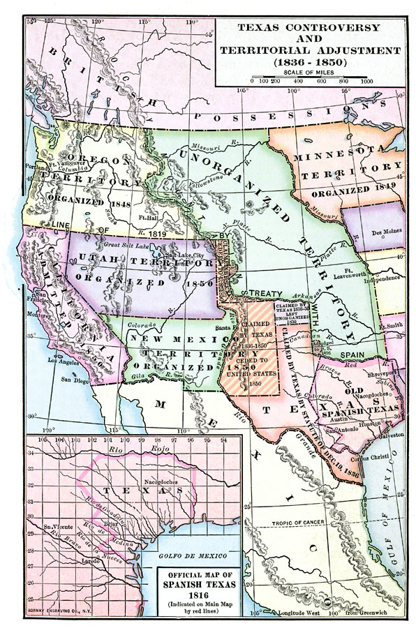
Description: A map of the western United States between 1836 and 1850 showing the Texas controversy and territorial adjustments at the time. The map is color–coded to show the unorganized territory of the Louisiana Purchase and the boundary line with the Spanish possessions established in 1819, the territories claimed by the Republic of Texas in 1836, the Oregon Territory organized in 1848, the Minnesota Territory organized in 1849, California admitted to the Union in 1850, and the territories of Utah and New Mexico organized in 1850. The territories of the Republic of Texas are also color–coded to show the portions claimed by Texas in 1836 and ceded to the United States in 1850, the territory claimed in 1836 and left unorganized in 1850, the small section adjusted to the United States in 1896, and the boundaries of the old province of Spanish Texas. An inset map shows the territory of the Province of Spanish Texas in 1816 prior to being ceded to Mexico in 1821.
Place Names: Growth of Nation, Houston, �Portland, �San Diego, �Los Angeles, �California, �Texas, �Spanish Territory, �New Mexico, �Oregon Countr
ISO Topic Categories: boundaries,
inlandWaters,
location,
oceans
Keywords: Texas Controversy and Territorial Adjustment, physical, �political, physical features, country borders,
major political subdivisions, boundaries,
inlandWaters,
location,
oceans, Unknown, 1836–1850
Source: Albert Bushnell Hart, LL.D., The American Nation (New York, NY: Harper and Brothers, 1906) 104
Map Credit: Courtesy the private collection of Roy Winkelman |
|
