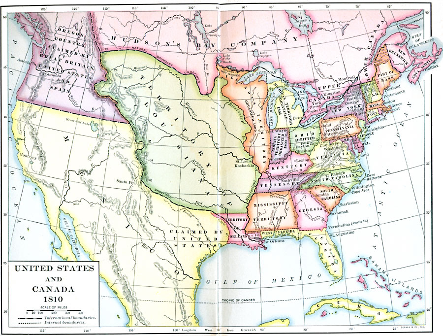
Description: A map of southern Canada, the United States, and northern Mexico showing the boundary disputes and territorial claims at the time of President James Madison (1810). The map shows the International boundaries and internal boundaries at the time, major cities and settlements, territories, and disputed boundary claims. The Oregon Country is shown as claimed by Great Britain, United States, and Spain. The border between the Hudson Bay Company and the Territory of Louisiana and Illinois Territory (organized 1809) is shown as undefined and unmarked. The boundary claims between Quebec, New Brunswick, and Maine (part of Massachusetts) is shown. The territory of West Florida between the Pearl River and Mississippi River is shown as seized by the United States in 1810. The Mexican territory west of the Sabine River (boundary established by the Louisiana Purchase of 1803) to the Rio Grande is shown as claimed by the United States.
Place Names: A Regional Map of North America, Canada, �United States, �Mexico, �Cuba, �Bahama
ISO Topic Categories: boundaries,
oceans,
inlandWaters,
location
Keywords: United States, Mexico, and Canada, physical, �political, physical features, country borders,
major political subdivisions, boundaries,
oceans,
inlandWaters,
location, 1810
Source: Albert Bushnell Hart, LL.D., The American Nation Vol. 13 (New York, NY: Harper and Brothers, 1906) 6
Map Credit: Courtesy the private collection of Roy Winkelman |
|