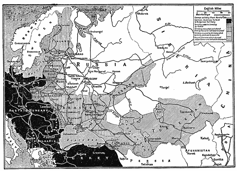
Description: A map showing Russia as it was partitioned by the treaty between the Germans and the Bolsheviki signed at Litovsk (Treaty of Brest–Livosk), March 3, 1918. This map shows the Eastern Front, with the German military line on March 15, 1918, the German, Austrian, Turkish, and Bulgarian territories, the territory ceded to Germany by Russia (Courland, Lithuania, Poland, Bessarabia, and territory near Ardahan on the Black Sea), the territory evacuated and abandoned by Russia for "self–determination," (Finland, Esthonia, Livonia, and Ukraine), the territory occupied by Germany which Germany promised to evacuate (White Russia west of the German front), and the Russian provinces which claimed independence and defied the Bolsheviks (Cossacks, Caucasus, and Turkestan). The map shows important cities, main railways, rivers, and large bodies of water.
Place Names: Eastern Europe, Austria, �German, �Poland, �Ukraine, �Russi
ISO Topic Categories: boundaries,
transportation,
inlandWaters,
location,
oceans
Keywords: Russia Partitioned, physical, �political, �transportation, kWWI, physical features, country borders, railroads, boundaries,
transportation,
inlandWaters,
location,
oceans, Unknown, 1919
Source: Charles Morris, Winston's Cumulative Encyclopedia Vol 9 (Philadelphia, PA: The John C. Winston Company, 1919) tab 2
Map Credit: Courtesy the private collection of Roy Winkelman |
|