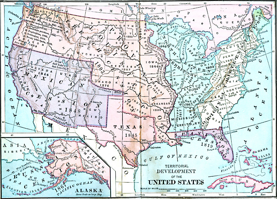
Description: A map from 1889 of North America showing the expansion in the region of the United States from the original Thirteen Colonies at the end of the Revolutionary War in 1783 to the time the map was made, around 1889, before the territories of Wyoming, Utah, Oklahoma (Indian Territory), New Mexico, Arizona, Alaska, and Hawaii gained statehood. The map is color–coded to show the original Thirteen Colonies and the North–Western Territory, and territorial acquisitions with dates given for the Province of Louisiana (1803), Spanish Florida (1819), Texas (1845), Mexican Territories (1848), and Alaska (1867). The dates of statehood for those states before 1889 is given, which include North Dakota, South Dakota, Montana, and Washington.
Place Names: Growth of Nation, Province Louisiana French Cession, �Mexican Cession, �North Western Territory, �Texas, �Mexico, �Russian Cession, �Pennsylvania, �North Carolina, �New York, �Boston, �Philadelphia, �Maryland, �Raleigh, �South Carolina, �South Western Territory, �Washi
ISO Topic Categories: oceans,
location,
inlandWaters
Keywords: Territorial Development of the United States, colonies, �development, �historical, �territory, other military,
historical event,
Civil War, oceans,
location,
inlandWaters, Unknown, 1783–1889
Source: A. S. Barnes, A Brief History of the United States (New York, NY: American Book Company, 1885)
Map Credit: Courtesy the private collection of Roy Winkelman |
|