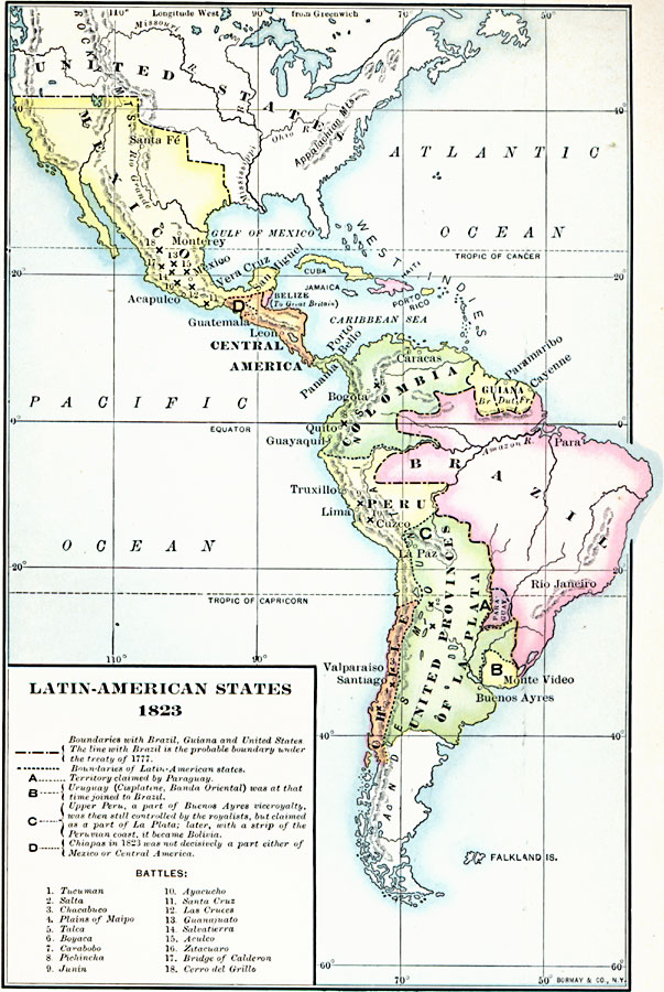
Description: A map from 1906 showing the political boundaries in Mexico and Latin America in 1823. The map shows national boundaries established in Brazil (Rio de la Plata region) between Spain and Portugal under the Treaty of San Ildefonso (1777), and the boundaries of the First Mexican Empire (1822-1823) established after the Mexican War of Independence. The map shows the British possession of Belize. The Latin American states shown include Columbia, the Guianas (under British, Dutch, and French control), Brazil, Chile, and the United Provinces of La Plata (1819 – 1826, then became Argentina. Patagonia was unclaimed until Argentinean and Chilean expansion between 1840 and 1902). The map is keyed to show the territories claimed by Paraguay (A), which declared independence in 1811. Uruguay (Cisplatina, Banda Oriental) was at that time joined to Brazil (B). Upper Peru, a part of Buenos Ayres viceroyalty, was then still controlled by the royalist, but claimed as a part of La Plata; later (1825), with a strip of the Peruvian coast, it became Bolivia (C). In the north, Chiapas in 1823 was not decisively a part of either Mexico or Central America (D). This map also shows the sites of significant battles in Latin America, including Tucuman and Salta in La Plata, the battles of Chacabuco, Plains of Maipo, and Talca in Chile, Boyaca, Carabobo, and Pichincha in Columbia, Junin and Ayacucho in Peru, and the Mexican battlefields of Santa Cruz, Las Cruces, Guanajuato, Salvatierra, Aculco, Zitacuaro, Bridge of Calderon, and Cerro del Grillo.
Place Names: Regional Americas, South America, �North Americ
ISO Topic Categories: physical, �political, kWorldAmericas
Keywords: Latin American States, physical, �political, physical features, country borders, physical, �political, kWorldAmericas, Unknown, 1823
Source: Albert Bushnell Hart, L.L.D., The American Nation Vol. 13 (New York, NY: Harper and Brothers, 1906) 286
Map Credit: Courtesy the private collection of Roy Winkelman |
|