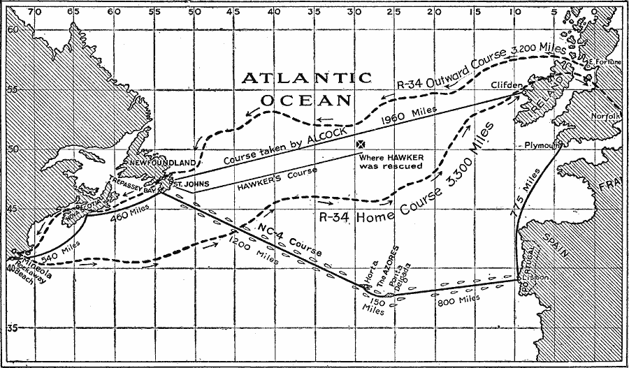
Description: A chart of the routes of the earliest transatlantic fliers. In 1919, the Atlantic Ocean was crossed by airplane and dirigible, British and American aviators sharing the honors. The chart shows the route of the NC–4, a United States Navy Curtiss NC flying boat commanded by Albert Read (May 8–31, 1919), from Rockaway, NY, to Plymouth, England via Lisbon, Portugal, the failed attempt by Harry Hawker in a Sopwith Atlantic biplane (May 18, 1919), the first non–stop flight by the British team of John Alcock and Arthur Brown in a Vickers Vimy bomber (June 14–15, 1919), between St. Johns, Newfoundland and Clifden, Ireland, and the route of the first double–crossing and east–to–west transatlantic flight by the dirigible R–34 commanded by Major George Scott in July, 1919 from East Fortune, Scotland to Mineola, Long Island, then returning to Norfolk, England.
Place Names: Regional Atlantic Ocean, North America, �Europ
ISO Topic Categories: transportation, �political, kWorldAtlantic
Keywords: Early Transatlantic Flights, transportation, �political, physical features, country borders, air routes, transportation, �political, kWorldAtlantic, Unknown, 1919
Source: Charles Morris, Winston's Cumulative Encyclopedia Vol 1 (Philadelphia, PA: The John C. Winston Company, 1919) tab 13
Map Credit: Courtesy the private collection of Roy Winkelman |
|