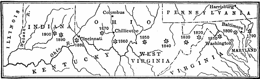
Description: A map from 1919 showing the mean center of population of the United States, calculated at each census from 1790 to 1900. The map illustrates the westward expansion of territory and migration during the period. "The center of population moved a greater distance westward in the fifties [1850] than in any decade in our history. In 1800 the center of population was about eighteen miles west of Baltimore; by 1840 it had crossed the Alleghanies; in 1850 it had reached Parkersburg, West Virginia; and in 1860 it was half–way across the State of Ohio." — Forman, 1919, p. 413.
Place Names: Demographics, Indiana, �Kentucky, �Maryland, �Ohio, �Pennsylvania, �Virginia, �West Virginia, �populatio
ISO Topic Categories: oceans,
location,
inlandWaters,
boundaries
Keywords: Center of population, borders, �historical, �physical, �population, �statistical, kPopulation, physical features, population, historical event, oceans,
location,
inlandWaters,
boundaries, Unknown, 1790–1900
Source: S.E. Forman, Advanced American History (New York, NY: The Century Company, 1919) 413
Map Credit: Courtesy the private collection of Roy Winkelman |
|