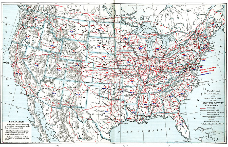
Description: A map from 1901 of the United States showing population density, railroad lines, state capitals, and census centers of population at the time. The red figures indicate the mean population density per square mile for each state according to the census of 1900, the blue figures indicate the percentage of increase of population per square mile between 1890 and 1900, and the red stars with figures indicate the mean center of population for each census from 1790 to 1900. The map shows major cities, indication those with populations less than 20,000, those with populations of 20,000, and in cases where the population exceeds 20,000, the relative population is indicated by the size of the circle. Primary railroads are shown with red lines, secondary railroads are shown with dotted black lines.
Place Names: Demographics, Boston, �Chicago, �Houston, �Los Angeles, �Miami, �New Orleans, �New York, �San Diego, �Seattle, �Washington D.C., �population, �census, �population density, �railroads, �capital
ISO Topic Categories: oceans,
location,
inlandWaters,
climatologyMeteorologyAtmosphere
Keywords: The United States Population and Railroad Network, borders, �physical, �political, �railroads, �statistical, �transportation, kPopulation, kTransportation, physical features, country borders, railroads, rainfall, oceans,
location,
inlandWaters,
climatologyMeteorologyAtmosphere, Unknown, 1901
Source: James A. Bowen, Grammar School Geography (Chicago, IL: Rand, McNally & Company, 1901) 80-81
Map Credit: Courtesy the private collection of Roy Winkelman |
|