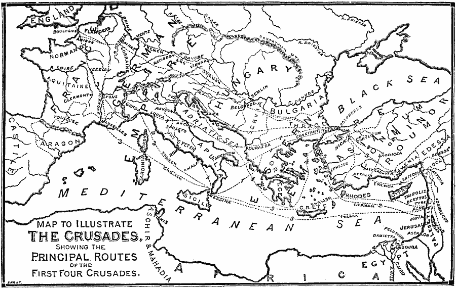
Description: A map of the Mediterranean region showing the principal routes of the European Crusaders to the Holy Lands during the first four Crusades, from 1095 to 1204. The map shows the various routes, indicating those of the Germans, French, and English, with the Crusade number given, and important cities and sites of the period, including Marseilles, Genoa, Rome, Venice, Constantinople, Edessa, Antioch, Acre, Joppa, and Jerusalem.
Place Names: Regional Mediterranean, Africa, �Asia, �Europ
ISO Topic Categories: physical, �political, �transportation, kWorldMedSea, kWorldEurasia, kWorldAfroAsia
Keywords: The Crusades, physical, �political, �transportation, physical features, major political subdivisions, water routes, physical, �political, �transportation, kWorldMedSea, kWorldEurasia, kWorldAfroAsia, 1095–1204
Source: William Swinton, Outlines of the World's History (New York, NY: Ivison, Blakeman, and Company, 1874) 252
Map Credit: Courtesy the private collection of Roy Winkelman |
|