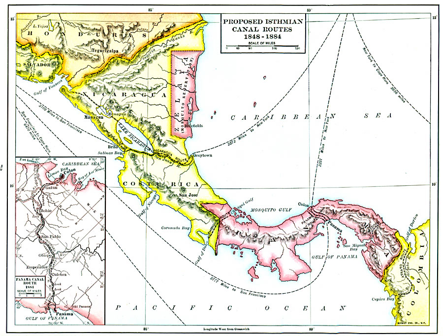
Description: A map of the proposed isthmian canal routes in Nicaragua and Panama between 1848–1884. The map shows the two chief proposals, the Nicaraguan from Greytown on the Caribbean to Lake Nicaragua and Brito on the Pacific, and the Panama proposal from Colon on the Caribbean to Panama City on the Pacific. Alternative routes are also shown, including an alternative in Nicaragua to the Gulf of Fonseca (Pacific), a route from Chirique Gulf, Panama, to the Gulf of Dulce, Costa Rica, an alternative western Panama route near Columbia called the Caledonia Route, and the proposed Atrato Route in northern Columbia. The map shows Zelaya (Mosquito Reservation) claimed by Jóse Santos Zelaya López in 1894 as a sovereign nation. The map also shows the naval distances to New York and San Francisco that would be effected by a trans–isthmus crossing rather than the traditional Cape Horn route. An inset map details the proposed Panama route in 1884. "The interest in a seaway from the Caribbean to the Pacific, which dated back to the days of Columbus, became more acute after the acquisition of California and the discovery of gold. Several routes were projected, and the Clayton–Bulwer Treaty of 1850 was intended to apply to any of them. But the surveys made between 1870 and 1875 showed that only those traversing Nicaragua and Panama, a part of Columbia, were of practical consideration, the preference being given at first to the former, though it would require locks to lower boats from the lake to the western ocean. An international conference, in 1879, decided that a sea–level canal be built from Colon to Panama, and construction was begun by a European company in 1888, though its slowness was discouraging. Americans as late as 1900 planned a canal by the Nicaragua route, some work was begun, and finally Congress authorized its support in 1902, if no arrangement could be reached with Columbia as to the Panama route." — Fox, 1920, pp. 178–179.
Place Names: A Regional Map of North America, Colombia, �Costa Rica, �Honduras, �Mosquito, �Nicaragua, �Panama, �Zelay
ISO Topic Categories: oceans,
location,
inlandWaters,
boundaries,
transportation
Keywords: Proposed Isthmian Canal Routes, borders, �transportation, �water routes, kCentralAmerica, water routes, oceans,
location,
inlandWaters,
boundaries,
transportation, Unknown, 1848–1884
Source: Dixon Ryan Fox, Harper's Atlas of American History (New York, NY: Harper & Brothers Publishers , 1920) 72
Map Credit: Courtesy the private collection of Roy Winkelman |
|