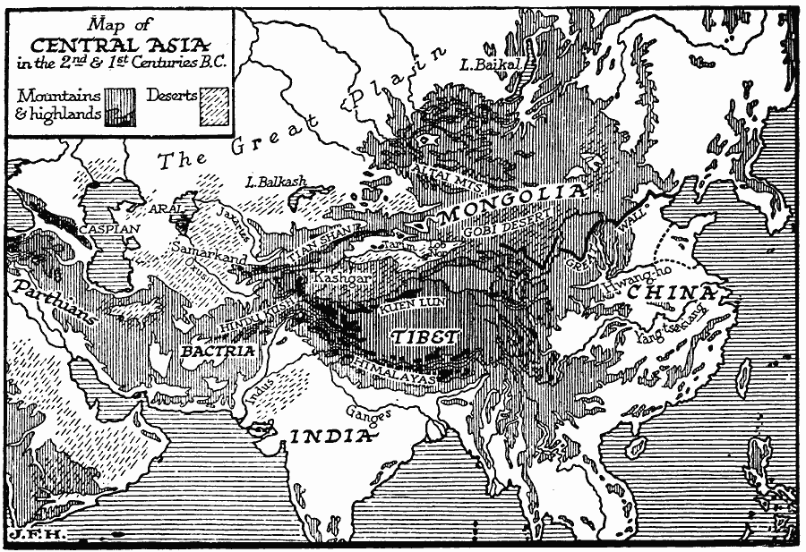
Description: A map of Central Asia during the first and second centuries BC showing the mountain systems, desserts, plateaus, rivers and terrain that hindered or motivated the Hun migrations to the west. "If the reader will examine the map of Central Asia, he will see that very great mountain barriers separate the Southern, Western, and Eastern peoples of Asia. (But he should be wary of forming his ideas from a map upon Mercator's projection, which enormously exaggerates the areas and distances of Northern Asia and Siberia.) He will find that from the central mountain masses three great mountain systems radiate eastward; the Himalayas going south-eastward, south of Tibet, the Kuen Lun eastward, north of Tibet, and the Thien Shan north-eastward to join the Altai mountains. Further to the north is the great plain, still steadily thawing and drying. Between the Thien Shan and the Kuen Lun is an area, the Tarim Basin (roughly Eastern Turkestan), of rivers that never reach the sea, but end in swamps and intermittent lakes. This basin was much more fertile in the past than it is now. The mountain barrier to the west of this Tarim Basin is high, but not forbidding; there are many practicable routes downward into Western Turkestan, and it is possible to travel either along the northern foothills of the Kuen Lun or by the Tarim valley westward from China to Kashgar (where the roads converge), and so over the mountains to Kokand, Samarkand, and Bokhara. Here then is the natural meeting-place in history of Aryan and Mongolian. Here or round by the sea." — Wells, 1920, p.546.
Place Names: Miscellaneous Asia, China, �India, �Mongolia, �Tibe
ISO Topic Categories: location,
oceans,
inlandWaters,
structure
Keywords: Terrain of Central Asia, physical, physical features, location,
oceans,
inlandWaters,
structure, Unknown, 200–1 BC
Source: H. G. Wells, The Outline of History (New York, NY: The Macmillan Company, 1921) 477
Map Credit: Courtesy the private collection of Roy Winkelman |
|