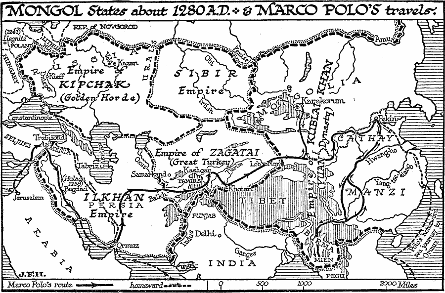
Description: A map of the Mongol states around 1280, during the time of Marco Polo's travels (1271–1295). This map shows the Empire Kipchak (Golden Horde), Siber Empire, the Empire of Kublai Khan (Yuan Dynasty) including Mongolia, Cathay, Manzi, Tibet, and Burma, the Ilkhan Empire in Persia, and the Empire of Zagatai (Great Turkey). The map shows the 1241 battle site of Liegnitz (Legnica), Poland, the farthest westward conquest of the Mongols in this part of Europe, and the Battle of Bagdad (1258) in which the Mongols, under Hulagu Khan, sacked the city. This map also shows the overland route of Marco Polo from Jerusalem to Karakorum and Pekin (Beijing), travels to Mien, Burma, and his homeward sea journey to Ormuz and then to Trebizond on the Black Sea.
Place Names: Miscellaneous Asia, China, �India, �Arabia, �Sibur, �Burm
ISO Topic Categories: boundaries,
location,
inlandWaters,
oceans,
transportation
Keywords: Mongol States , political, �physical, �transportation, physical features, major political subdivisions, boundaries,
location,
inlandWaters,
oceans,
transportation, Unknown, Around 1280
Source: H. G. Wells, The Outline of History (New York, NY: The Macmillan Company, 1921) 676
Map Credit: Courtesy the private collection of Roy Winkelman |
|