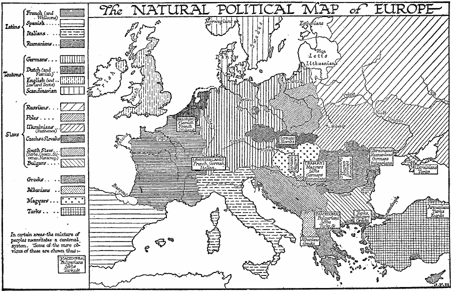
Description: A map of Europe by H.G. Wells showing what he felt was the natural political map of Europe based on ethnic homogeny. Wells grouped the territories as Latins (French, Spanish, Italians, and Rumanians), Teutons (German, Dutch, English, and Scandinavian), Slavs (Russian, Poles, Ukrainian, Czech and Slovak, South Slav, and Bulgar), Greeks, Albanians, Magyars, and Turks. Wells also shows areas where he felt a mixture of peoples necessitated a cantonal system. The map also show the territories of the Basques, Bretons, Irish, Welsh, Highland Scots, Esthonians, Letts, and Lithuanians.
Place Names: Western and Central Europe,
ISO Topic Categories: boundaries,
location,
oceans,
inlandWaters
Keywords: Natural Political Map of Europe, statistical, �physical, kEthnic, physical features, ethnological, boundaries,
location,
oceans,
inlandWaters, Unknown, 1921
Source: H. G. Wells, The Outline of History (New York, NY: The Macmillan Company, 1921) 921
Map Credit: Courtesy the private collection of Roy Winkelman |
|